Descenso de barrancos
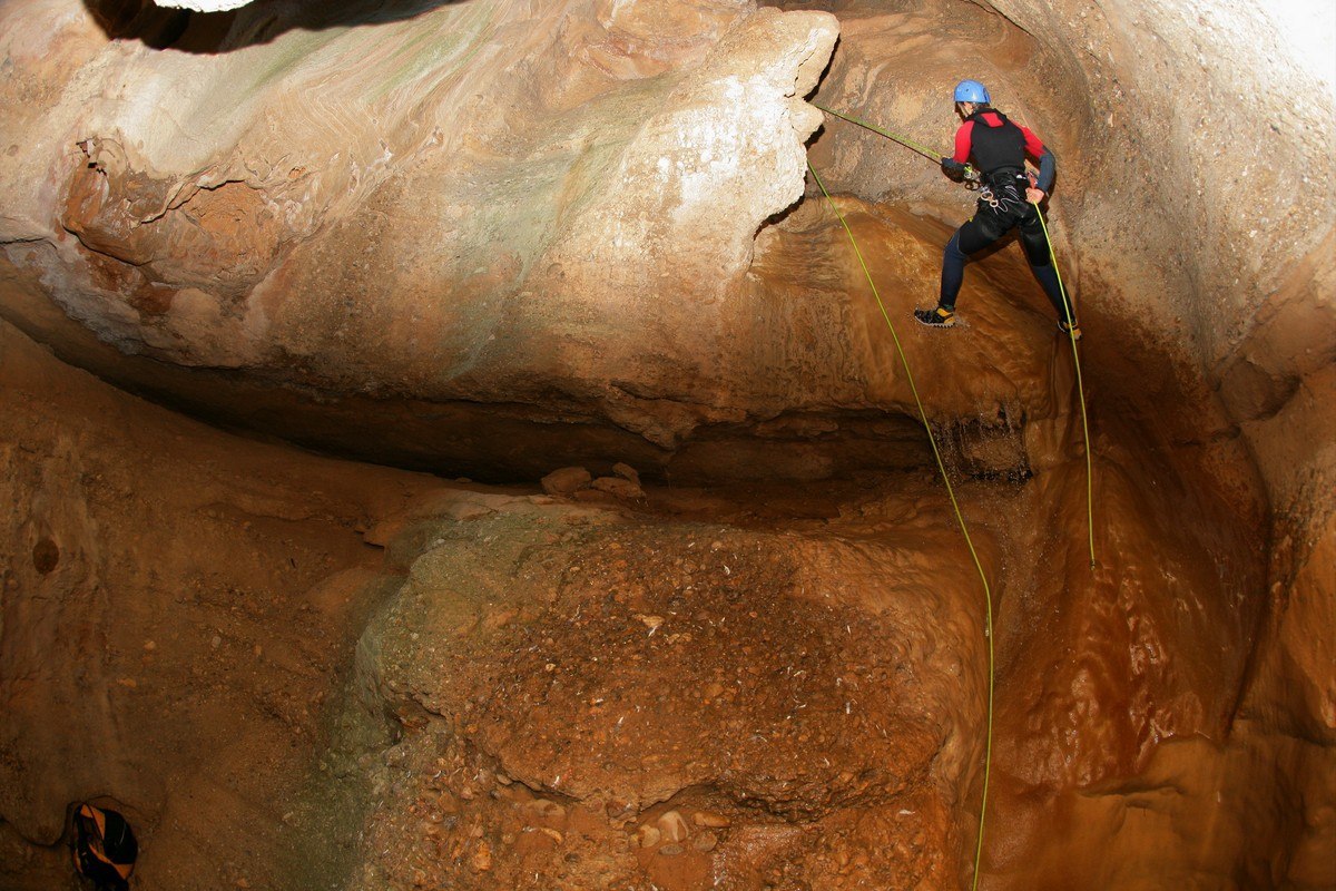
Oscuros de Balced

The canyon of the Oscuros de Balced is one of the prettiest and most popular in the Sierra de Guara. It is a relatively short but comprehensive in terms of attractions, offering jumps, drops and “chaos” (piles of large blocks of fallen rocks) as well as narrow passageways, siphons and pools of turquoise water. It is ideal for newcomers to the sport of canyoning although always taking the necessary security precautions and evaluating the strength and height of the water flow.
As this is one of the most popular routes in Guara, you should also take into consideration the amount of people in the canyon, especially in summer.
Downloads
Technical information
Approach: 1 hour. Arriving by car, the exit is signposted as “Collado Fondo” around the 9-10km mark on the road from Bierge to Rodellar. Follow the forest track that leaves from a small hillock (at the side of a rubbish bin covered with wood) and follow it for around 2.5km until arriving at the “Collado de Colmenares.” This is a small knoll with ruins to the right. You will see a footpath signposted to “Tranco de las Olas” which is the path used at the end of the descent. Continue on foot by following the path to the fence. Once you arrive at a curve in the path (which is closed off to the left) there is a well marked path to the right, which goes to the start of the descent. Nearest village: Las Almunias de Rodellar
Descent: 2 - 3 hour KM: 1500m
Retour: 45 minutos. From “Tranco de las Olas” take the return footpath to the forest track where you left your car.
Escape routes: None. During rainy periods, be vigilant regarding the water flow in the “Oscuros” as there are stretches that can become very dangerous with high water levels, especially the first rappel. Be prepared to make this descent under a flow of water.
Car combination n/a
Difficulty level: Medium in summer. Very high during and after heavy rain as this canyon is very susceptible to change after storms and the water flow can increase considerably.
Minimum equipment requirements:
- Full wetsuit and neoprene socks or canyoning shoes.
- Helmet
- Harness
- Double anchor lanyard
- Ropes
- Equipment for abseiling (figure-of-eight descender)
- 2 ropes of at least 15m in length.
- Waterproof canyoning backpack
- Watertight barrel
- Picnic and water
Points of interest
- Las Almunias de Rodellar
- Tranco de las Olas
- Somontano Natural Route
Photo gallery


Fondo

This is one of the tributaries to the right of the Balced canyon. This canyon has been patiently chiselled from conglomerate rock over thousands of years. It is a little known but very interesting canyon and should only be tackled by experienced canyoners as several of the drops are tricky and require technical abseiling techniques.
The scenery along the route is spectacular as the river bed is located at the bottom of a very deep, narrow and enclosed canyon. It is dry along most of the way, except for the last few pools, which have plenty of water that seeps from the rock.
Technical information
Approach: 5 minutes from the car park. The car park is located between the 9 and 10km mark of the HU-341road from Bierge to Rodellar, just at the fork from the knoll known as the “Collado Fondo.” (signposted) The closest village is Las Almunias de Rodellar. Leave the car near to the start of the forest track at the side of the wooden shelter for rubbish bins. Nearest village: Las Almunias de Rodellar
Descent: 3h - 3h:30 min KM: 1200m
Return
- 2 hours if not using two cars.
- 1 ½ hours if a car has been left at the end of the forest track.
- Follow the Balced River back upstream, in the water or along the footpath that follows the river on the right hand bank, until reaching the exit from the Oscuros de Balced canyon (“Tranco de las Olas”) Take the same footpath to return to the track that leads back to the car park.
- During or after heavy rain, the level and speed of the water flow in the Balced should be checked carefully.
Escape routes: There is an escape route for extreme emergencies but it is not recommended as it is very exposed and dangerous and requires rock climbing techniques to be used.
Car combination:It is not really necessary to take two cars unless you wish to save 30 minutes on the return journey. In this case, leave a second car at the end of the forest track (the same place used for the descent of the Oscuros de Balced.)
Difficulty level: very high in any season of the year. The use of a local guide with experience is highly recommended.
Minimum equipment requirements:
- Helmet
- Harness
- Double anchor lanyard
- Ropes
- Equipment for abseiling (figure-of-eight descender)
- 2 ropes of at least 30m in length.
- Self-braking descender
- Wetsuit:
- Full wetsuit with neoprene socks in during cold periods.
- Neoprene trousers and bib in the summer.
Points of interest
- Las Almunias de Rodellar
- Tranco de las Olas
- Sierra de Balced
- Somontano Nature Route
Photo gallery


Cueva Cabrito

The CabritoCave canyon is one of the most difficult descents of the Balced basin, and only suitable for those in top condition and with plenty of experience. Sculpted from conglomerate rock, the canyon is dry during most of the year, and only features water after rainy periods. It is without doubt, one of the best conglomerate canyons in the whole of the Sierra de Guara.
Chimney climbing is necessary along the length of the route, especially in the long central passage as a sustained effort is needed. Although short, the rappels require great technical expertise. This canyon provides plenty of obstacles and requires a lot of athleticism for those descending.
Pay special attention to the water flow, especially during and after heavy rain and periods of high water are best avoided as the water pools flood.
One of the most spectacular spots along the route is the impressive “hall” or shelter in the final stretch, although the narrows along the full length of the descent are of equal beauty.
Technical information
Approach: around 20 minutes until the start of the canyon descent. Park the car just before the 8km mark on the road from Bierge to Rodellar; there is a levelled-of area with a large holm-oak to the right of the road. Take the descending path and cross the fence; you will see a farm at this point. The footpath leads off to the right and goes all the way to the river bed. Nearest village: Las Almunias de Rodellar.
Descent: 3-4 hours KM: 1800m
Retour: 1h:30 min walk along the path on the left hand bank of the river (5 minutes upstream there is a footpath on the right hand bank that is clearly marked with stones). Or 1 ½ hours along the more popular route, which involves swimming across the river at the Cautiecho narrows. In both cases, the exit is upstream unless doing an additional decent down the Balced narrows.
Escape routes: There is only one escape, just before the final narrows, on the left hand bank of the river.
Car combination n/a However, this route can be combined with a descent of the Balced narrows; in this case a second car should be left by the bridge at Alberuela de Laliena (in the direction of Bierge.)
Difficulty level: very high in any season of the year. The use of a local guide with experience is highly recommended.
Minimum equipment requirements:
- Helmet
- Harness
- Double anchor lanyard
- Ropes
- Equipment for abseiling (figure-of-eight descender)
- 2 ropes of at least 15m in length.
- Self-braking descender
- Picnic and water
- Wetsuit:
- Full wetsuit with neoprene socks in during cold periods.
- Neoprene trousers and bib in the summer.
Points of interest
- Sierra de Rufas
- Las Almunias de Rodellar
- Holm oaks and strawberry trees
Photo gallery


Palomeras del Fornocal
The Palomeras de Fornacal highlights that a short canyon can be every bit as interesting as other longer canyons in the area. It is a spectacular gorge chiselled from conglomerate rock and obviously well weathered. It’s at its best after rain and is considered to be one of the essential routes in the eastern region of the Sierra de Guara.
The route requires chimney climbing in parts and is both attractive and enjoyable along the whole of the route. In addition, it can easily be combined with other descents nearby.
It can be enjoyed throughout the whole of the year but is best after rain as the pools often become stagnant in dry periods due to the minimal flow of water.
Technical information
Approach: the access to the start of the canyon is almost immediate, although take care as the terrain is loose underfoot and can be tricky. Leave the car on the small, levelled area between the 26 and 27km mark on the road from Colungo to Arcusa, at the bridge with the sign for “Barranco de la Palomera.” Nearest village: Colungo, on the way Asque.
Descent: 1h:15min KM: 300m
Return: 30 minutes; take the steep path that leads up to the road. Follow the road towards Colungo until reaching the bridge where the cars were left.
Escape routes: None. It is narrow and deep with a spectacular stretch of “oscuros” that has no escape or shelter.
Car combination n/a
Difficulty level: Low to medium level throughout the year.
Minimum equipment requirements:
- Full wetsuit with neoprene socks in during cold periods.
- Neoprene trousers and bib in the summer.
- Helmet
- Harness
- Double anchor lanyard
- Ropes
- Equipment for abseiling (figure-of-eight descender)
- 2 ropes of at least 10m in length.
Points of interest
- Colungo
Photo gallery


