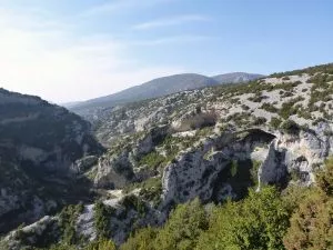
The wild beauty of their grandeur does not lie in the height of the mountain tops, but in the depth of their spectacular canyons, carved by the rivers, rain and wind.
The peaks and slopes of the Guara (1,870 mts. at the highest point, the Cabeza de Guara) are very rounded due to wear from strong winds and ice breaking off thousands of pieces of rock to form large scree slopes and gullies.
The peaks above Rodellar Valley receive large amounts of rainfall (1,000 mm per year) which quickly filters to the sub-soil, giving rise to underground rivers (karstic phenomena). Sometimes they re-surface in the form of upwelling (such as at Mascún, La Tamara and El Puntillo) in the beds of the same rivers that they feed.
When there is heavy rainfall, the water that has filtered deep into the mountains wells up through gullies and open cracks in the slopes, known locally as solencios, and become large rivers or waterfalls (Solencios Pedruel and Morrano).
The rivers had to force a way through cracks in the limestone ground in order to continue their path, breaking up the rocks through action of cold water over millions of years, and carving out deep ravines, gorges and falls. The water bored through the rock and polished it, creating passages and chutes, and the stones crashing together formed pot-holes, underground basins and beautiful natural pools.
Huge rocks fall into the ravines creating labyrinths, or caos, in the bed through which the water has to find a way out, giving rise to siphons. Gorgas Negras, Mascún, Los Estrechos de los Fornazos, Los Oscuros de Balced, Fornocal ravine and the river Vero canyons are, because of their spectacular beauty, already legendary names in the long list of canyons which make the Reserve a paradise for fans of adventure sports.
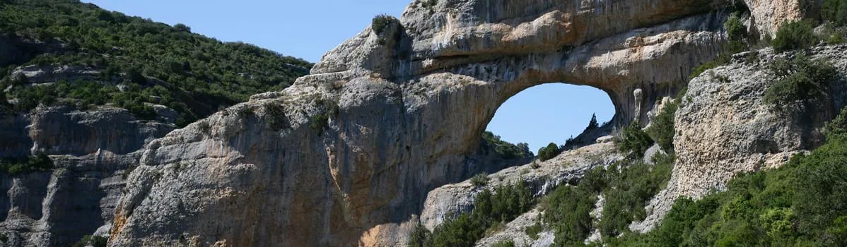
When the water goes through the limestone at the exit of the ravines, impressive vertical cliff faces are formed, sharp crests (Ciudadela de Mascún) and rock needles (Cuca de Bellosta in Mascún), open cavities in the farallones (rock walls of the river Vero), and hollows opened by differential erosion in the weakest horizontal strata of the crests, called foraus locally, or portals (Portal de la Cunarda in El Fornocal or Ventana de Mascún). There are also many “palomeras”, meaning dove-cotes, a name given in the area to these ravines on account of so many of the birds making their nests in the hollows and ledges. The rivers then open out into the valley between huge mounds of sedimentary, reddish-hued conglomerate rock, creating an impressive array of monoliths and vertical walls in the countryside. These watchtowers keep silent vigil over the geological kingdom of the Guara. One of the most spectacular is the Huevo de Morrano.
The abundance of fossils is another attraction provided by the mountains. In the Mesozoic age, part of the land was below the level of a warm sea, where many species of animals thrived: fossilised bi-valves, sea urchins and starfish can be found with ease. In a place called Mallata de los Dineretes are several nummulites, flat and round fossils, resembling small coins. It is important to point out that the fossils that lie within the boundaries of the park are protected by Aragonese Law and their removal is strictly forbidden.