Rutas en la Sierra de Guara
Ruta to Chimiachas. Alquézar
Technical information
Type of route: return hiking route
Departure point: Alquézar
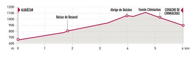
KM: 12,2
Duration: 5 h
Gradient: 650
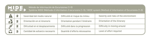
MIDE: 2-2-2-3
Difficulty:
Points of interest
Vantage point at Las Clusas (views of the sierras and the Vero canyon), the pools at Basacol, the caves at Quizans, the small cave in Chimiachas ravine.
Abrigos de Chimiachas y Quizáns
Route description
This walk starts and finishes in Alquézar. It is a route perfectly suited to hiking and passes through the ravines and peaks of the eastern area of the Guara Natural Park. Following the directions it is possible to enjoy the spectacular landscapes of the Cultural Park of the River Vero and to visit some of the most important prehistoric cave paintings within it. The importance of these paintings has resulted to the area being declared a UNESCO World Heritage Site.
The start of the path can be found just by the municipal swimming pools of Alquézar, where an information board shows details of the route. A little way along this path, you will come across the first of several cylindrical constructions of the walk. They are recreations of the typical huts once used by the shepherds of the Guara.
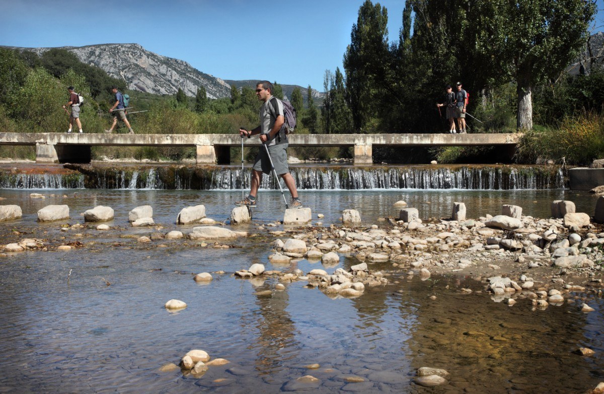
As you follow the path north along the route of an irrigation channel, a sweeping panorama of Alquézar will appear. You will come across a signpost that indicates the direction of the Balsas de Basacol (Pools of Basacol). This route will take you across a number of footbridges and over a small stone bridge spanning the Payuela ravine, before eventually bringing you to the pools. On warm days, this inviting water is a wonderful place to take a dip before continuing the climb towards the Quizans rock shelters.
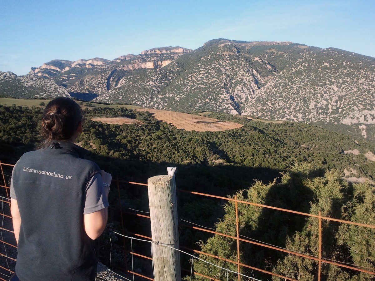
During the next section of the walk, you will be rewarded by superb views of the section of the canyon known as Las Clusas del Vero. The footpath then enters a thicket of juniper, boxwood, rosemary, lavender, kermes oak and evergreen oak before arriving at Quizans. A visit to the fascinating prehistoric rock paintings of Quizans can be made either on the way up to Chimiachas or on the return journey, as the route follows the same path.
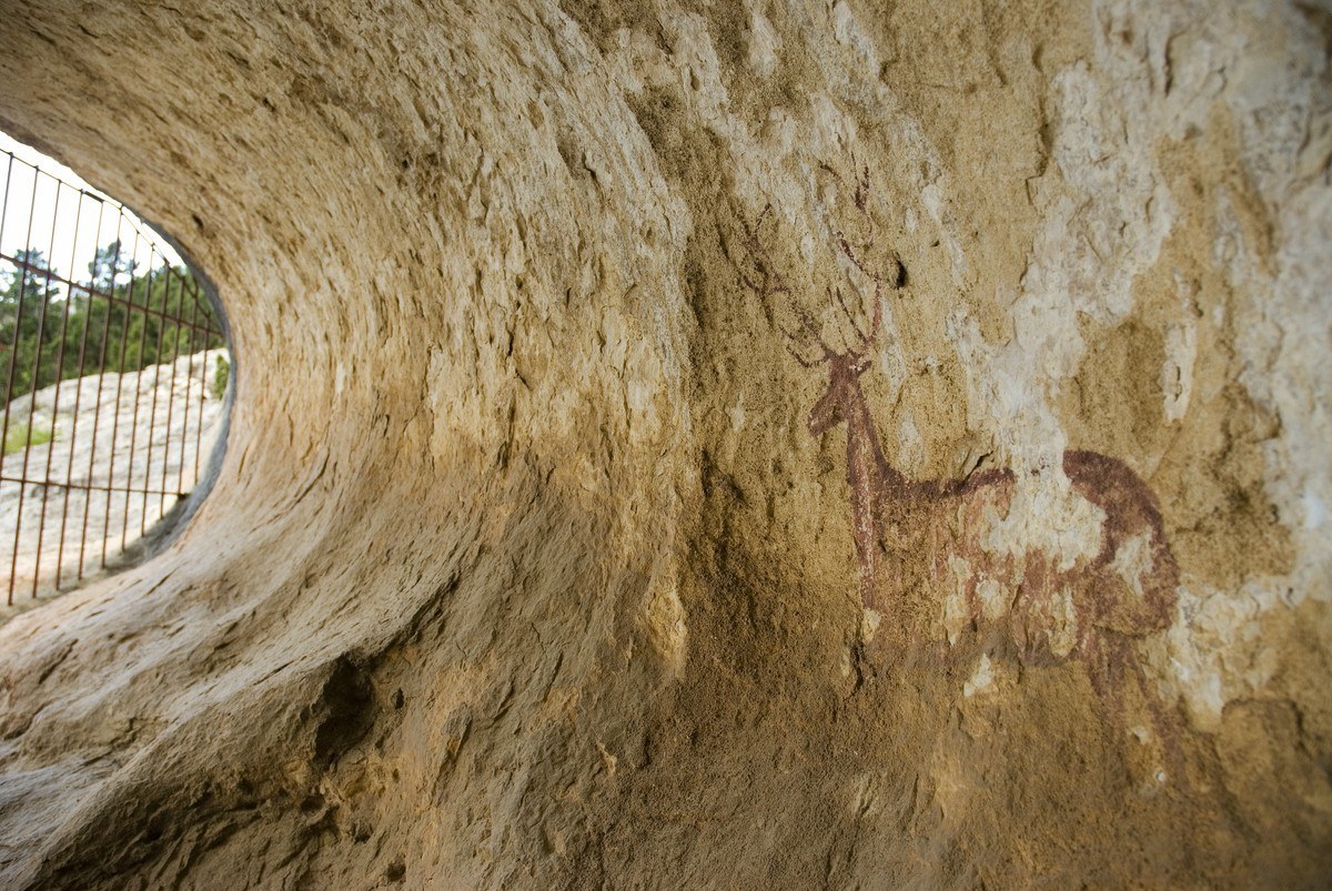
Following the signs you will arrive at the Tozal de ros Tiestos, a peak boasting magnificent views of the mighty Pyrenean mountains of the Monte Perdido and Ordesa National Park. You will then arrive at the head of the Chimiachas ravine where another cylindrical shepherd’s hut similar to the first can be found. Here, take the path heading down to the bed of the ravine, which leads to a small cave with a painting of a solitary and majestic deer. Chimiachas is a place full of magic and mystery set in the very heart of the Guara mountain range, and this work of art from the Levant period is one of the best examples to be found in the area. The majestic flight of the griffon vultures and choughs add to the potent atmosphere.
Photo gallery


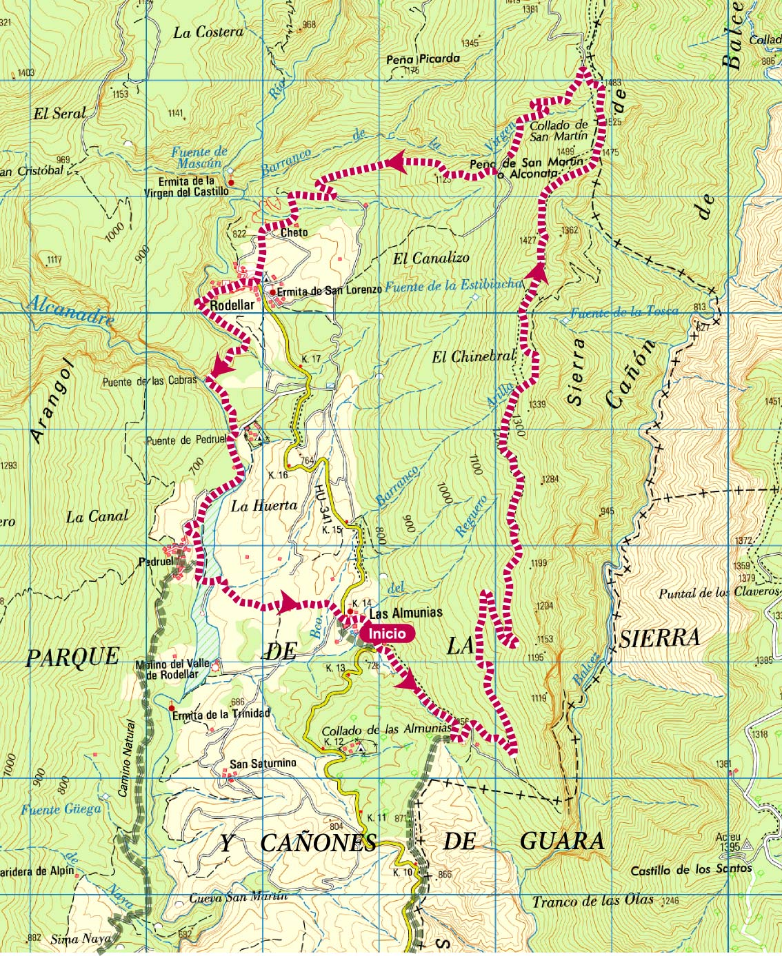
Map

Crest of Balced Route. Las Almunias de Rodellar
Technical information
Type of route: circular hiking and mountain bike route
Departure point:: Las Almunias de Rodellar
KM: 20,5
Duration: 8 h
Gradient: 950 m
MIDE: 3-2-2-4
Dififculty: +
Poitns of interest
Views of the Pyrenees, the sierras and the ravines of Guara.
Route description
The crest of Balced extends from north to south and sits between the Alcanadre and Isuala rivers. This route is well signposted and offers the visitor an extraordinary opportunity to experience one of the deepest and longest ravines of the Sierra de Guara, known as the Balced canyon. This walk also presents exceptional views of the Pyrenees, the Rodellar Valley and the highest peaks of the Guara Natural Park.
This particular route is linear and can be started from either Rodellar or Las Almunias de Rodellar. As it does not loop back to the original starting point, it is advisable to have more than one car available so that a vehicle can be left at each end of the route.
For those walkers starting the walk in Las Almunias de Rodellar: head out of the village on the main road to Bierge and after 200 metres you will come across a signposted footpath to the left of the road. Walk along this footpath until you arrive at an old track; this was once used by charcoal merchants heading to the mountains. Continue along this track in a northerly direction and as it climbs gently up a west-facing slope you will be rewarded with sweeping views of the Rodellar Valley and the surrounding mountains.
As you get closer to the crest you will find that the track stops suddenly. In its place there is a smaller footpath heading in the same direction, which will take you to the highest point of the walk. From this lofty spot, the grandeur of the Balced canyon can be appreciated in full. The graceful flight of the various birds of prey that make their nests on the ledges of the crest will also impress. Griffon vultures, lammergeyers (also known as bearded vultures) and royal eagles are just a few of the species to be found here.
Following the markers, you will come across an arrow that indicates the descent towards Rodellar. On the way to the village there are a number of well-built dry-stone walls, erected to mark out and protect the paths and the small parcels of cultivated land.
Photo gallery


Map
Routes around Sierra de Guara
Sierra and Canyons de Guara Natural Park, with its astonishing rocky cliffs sculpt by water, has plenty of singular landscapes crossed by marked paths: Mascún ravine, Balced peaks, Tamara and Puntillo springs, Vero canyon, the Cunarda, etc.
Surrounding Bierge, Rodellar, Alquezar or Colungo, through its network of marked paths, unique landscapes are discovered, abysses which are shelter for flora and fauna, cave art, crenellated towers and walls, chapels, traditional architecture, legends about maidens, ghosts and Moorish…

