Rutas en el Somontano
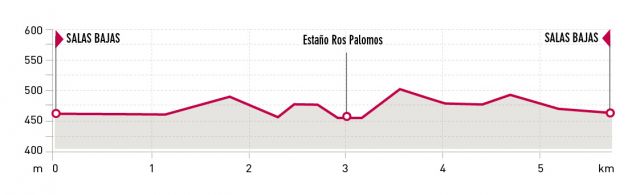
Estaño ros Palomos Route. Salas Bajas

Technical information
Type of route: circular hiking and mountain bike route.
Departure point: Salas Bajas
KM: 5,7
Duration: 1h 30 min
Gradient: 100 m
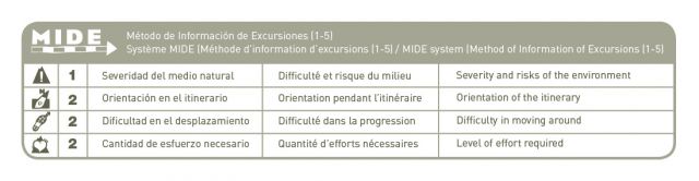
MIDE: 1-2-2-2
Difficulty:
Points of interest
Vineyards , groves of oaks , ancient olive groves .
Route description
This route, of a little more than 6kms takes us from the outskirts of Salas Bajas to a magical place in the Ariño Canyon called el Estaño ros Palomos. Access can also be gained by the old path to Hoz de Barbastro“el antiguo camino a Hoz de Barbastro”or by the Montesa path.
Along the short walk you will be well rewarded when you arrive at the cascade, which feeds an enormous swimming hole.Next to it, is the opening of a huge cave that was given the name of this place because wood pigeons used to make their nests here. But this is not the only charming part, as throughout the trip you will encounter vineyards, small holm oak forests,small rock dwellings and century old olive trees.
Whatever path you choose you will have to walk short parts alongside the road. Please remember that as a pedestrian you must walk on the right left side and cross the road with caution.
If you like hiking around Salas Bajas, take the Ermitas Route which is 21 kilometres long, linking the towns of Buera, Salas Altas, Pozán de Vero and Castillazuelo. Needing not even half a day and through a simple itinerary, suitable for everyone, one can discover five different chapels laden with history.
Photo gallery


Map

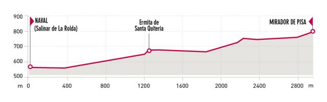
Pisa Lookout (Mirador de Pisa). Naval
Ficha Técnica
Type of route: lineal hiking route
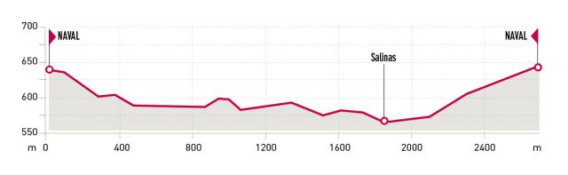
Departure point: Naval, Salinar de la Rolda
KM: 5,6
Duration: 2 h
Gradient: 250 m
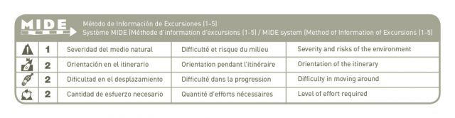
MIDE: 1-2-2-2
Difficulty:
Points of interest
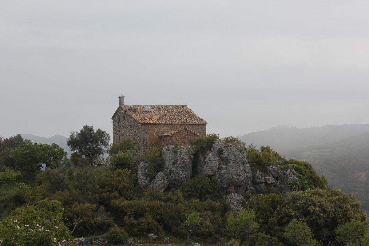
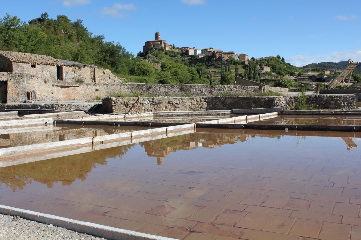
Salt production, Santa Quiteria chapel, old trenches “trincheras”from the Civil war and spectacular views on Naval, the Sierras and the Pyrenees.
Route description
The town of Naval is known for its tradition of ceramics and salt extraction and itsfrom the Salinar de la Rolda (the salt baths) the hiking trail begins. It takes us to some old Civil War trenches and from here, one can enjoy spectacular views of the Pyrenees.
From the lookout, the path takes us to the Santa Quiteria chapel, dating back to the 16th century. It underwent some modifications in the 18th century. It has a rectangular nave covered by a star shaped vault (apsidal section), lunette (rest of the nave); a chapel and sacristy attached to the southern part of the building. A procession takes place here on the 22nd of May or the closest Sunday.
Photo gallery


Map

The salt route. Naval
Technical information
Type of route: circular hiking route.
Departure point: Naval, Plaza Mayor y calle Santo Cristo
KM: 2,7
Duration: 1 h
Gradient: 120 m
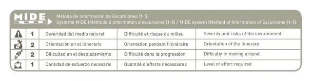
MIDE: 1-2-2-1
Difficulty:
Points of interest
The banks of the Llastre (fauna and flora), the salt beds, orchards, farmland and Salinar de la Rolda.
Route description
The educational Salt Route leaves from the Calle de Santo Cristo in the centre of Naval. It is well signposted and dotted with information panels, helping the visitor to understand the natural and cultural importance of this unknown corner of Somontano.
Following the path, you will soon arrive at the salt beds of Naval. The route passes close to the River Llastre where many different species of tree and bush can be found, such as poplar, ash and willow.
The path passes under the bridge that carries the road over the water. Just a few minutes walk from here you will cross the river to arrive at La Rolda Viewpoint,which affords clear views over the whole of the salt production area.
From the viewpoint the path winds its way down between the salt beds of La Rolda and Pisa, before arriving back at the River Llastre. Set between fertile vegetable gardens marked out by old stone walls, the path arrives at a wooden bridge. Crossing this will bring you to the steep asphalt road which leads back into the town centre.
Traditional methods of production are still used in the ancient salt beds of Naval. The history of Naval is inextricably linked with the production of salt, which although unconfirmed, is said to date back to the 11th century. These installations were created in order to exploit a number of saline springs that had risen to the surface at the foot of the mountains. It was also necessary to build a number of other structures to assist in the production process, such as pools and salt stores. The extraction of salt has always been an important source of income for many families in Naval.
Photo gallery


Map

Sierra de Estada route
Technical information
Type of route: circular hiking and mountain bike route.
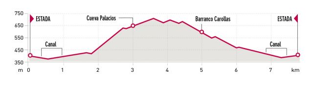
Departure point:: Estada, Plaza Mayor
KM: 7,8
Duration: 3 h
Gradient: 400 m
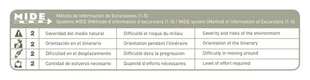
MIDE: 2-2-2-2
Difficulty:
Points of interest
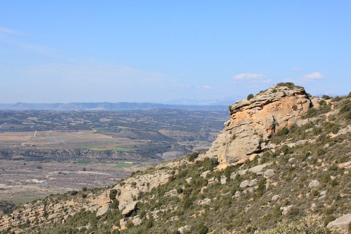
The countryside and panoramic views of the Sierra de Guara and the Pyrenees, birdwatching (kestrels, Griffon vultures, red kites, buzzards, etc), huts and pens, Palacios cave.
Route description
Almond tree groves, fields of crops and old cattle grazing areas make up the first part of the route as it climbs steadily, reaching 700 metres above sea level at its highest point. From here it starts to gently descend, snaking between olive groves and thickets. You will soon come across the Palacios cave, which sits above the canyon and boasts magnificent views of Somontano, the Sierra de Guara and a section of the Pyrenees.
Finally, the path winds along the side of the canyon and joins a track that returns back to Estada.
Photo gallery


Map


