Technical information
Type of route: lineal hiking route
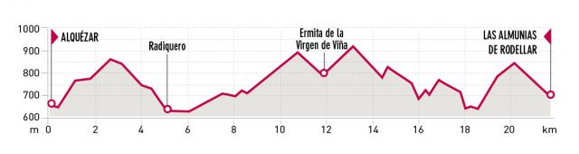
Departure point: Alquézar
KM: 22
Duration: 8 hours
Gradient: 950 m
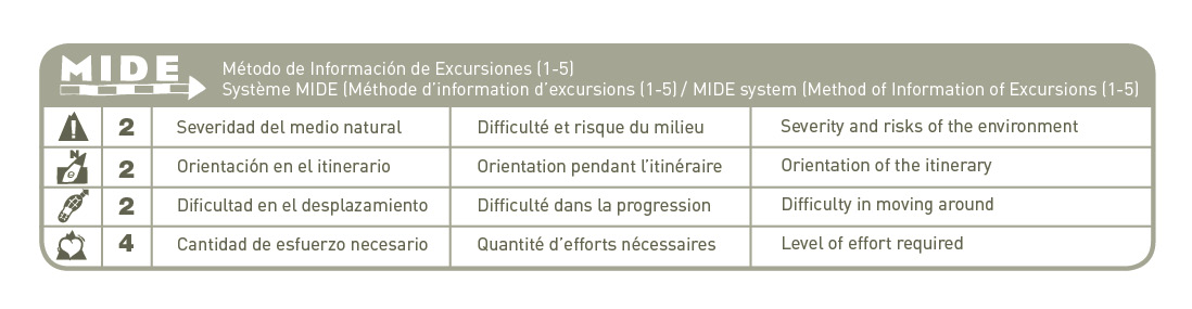
MIDE: 2-2-2-4
Dfficulty:
Points of interest
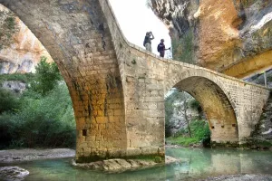
Village of Radiquero, chapel “Ermita de la Virgen de la Viña”, Cautiecho canyon, bridge “el Puente de las Bruxas” and Tranco de las Olas.
Route description
The path follows the San Gregorio path arriving in Radiquero, the Santa Águeda chapel and continues to “la cabañera” (herdsman trail) that linked the low lands (Mequinenza) to the Pyrenees (Broto). The path then diverts, to cross the Canyons of Modovil and Avellaneras, and passes closeby the chapel “Ermita de la Virgen de la Viña”.
From Corral Nuevo, the path continues passing by the palomeras, spectacular karst formations until the narrow pass of the Cautiecho canyon, crossing over the bridge “el Puente de las Bruxas”. In the past, mules and their drivers, loaded with olive oil, flour, wine, potatoes or honey could easily cross this crevice thanks to this simple ingenious and practical bridge, showing us one of the most archaic building solutions used by man to cross and overcome the abysses of the sierra.
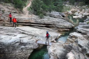
With a smooth descent we reach the riverbed of the Isuala Balcés river at the elevation of a Tranco de las Olas, by which the path crosses toward the Collado de las Almunias. This was the traditional way to avoid a difficult stretch when the river Isuala-Balced was swollen..The name of the place refers to the type of construction, consisting of a simple log attached to the rock with metallic hooks, a temporary structure, that would be taken away with eachflood in the canyon. From there, we continue on the track toward Las Almunias de Rodellar.
Photo gallery


Map