Ruta de los Castillos
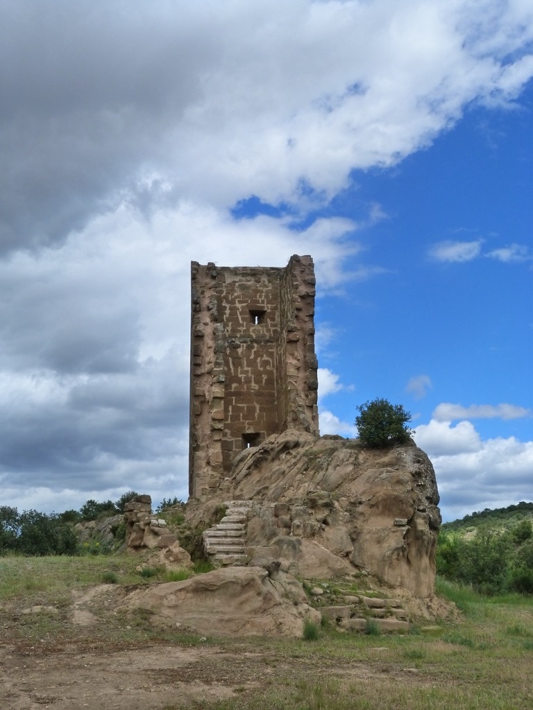
Farnagüelo Tower. Azlor
In Somontano there are remains of numerable defensive constructions such as walls and rock platforms with notches and putlog holes. These are testimony to the struggle between Islam and the Kingdom of Aragón for the control of the territory during the 11th and 12th centuries.
These castles and fortifications, often just a simple tower with a small enclosure, provided the means for scouting parties to gain ground as they advanced. Because of this they are located in entrances to river valleys and canyons, which were used for communication.
The 12th century Farnagüelo or Fernanvel Castle rises from a sandstone promontory at a height of 525 metres. It provided visual control of movement and communication between villages in the La Clamor canyon (Azlor, Azara and Peraltilla), the Vero Valley and the Sierra de Guara.
These small castles were small and very basic but contained everything they needed to resist besiege. Almost all had a fireplace, chapel, accommodation, primitive toilets, water tanks and food storage. The tower had limited interior space. It was constructed with a double wall made of ashlars and filled with boulders and mortar. Although robust there are currently only three walls still standing. Excavations have revealed the existence of a fortified enclosure that occupied the rocky platform and surrounded the tower.
Also uncovered was a staircase with ten steps made from lime-based concrete from a later period as well as a number of ceramic items from the 15th and 16th centuries; glasses, vessels, jugs and pots for storing liquids and food.
No evidence of a violent destruction or fire has been discovered, so it is unlikely that it was destroyed during battle. The absence of material in this area indicates that at some point the tower was abandoned through disuse.


La Torraza Archaeological site. El Tormillo

Between the years 1100 (year of the conquest of Barbastro) and 1134, Alfonso the Warrior led the expansion and development of the Alto Aragon region. By removing the Muslim threat he made way for confident repopulation and the expansion and control of the territories was achieved thanks to the creation of new settlements. These were usually in strategic locations in terms of their height, closeness to water and access to communications. The archaeological remains of La Torraza date back to the 12th century and should be considered in this context.
The nearby village of El Tormillo was also inhabited at the same time and the church was contemporary with the buildings of La Torraza. However, El Tormillo prospered while the village of La Torrazo faded and died.
Other similar settlements such as El Almerge (Laluenga), which was fortified, on a high slope and near water, was also abandoned but the reasons are unknown.
The site can be found on a long hill that runs north to south and covers an area of approximately 150 x 50 metres. Its name, Torraza, makes reference to the collection of stones and ashlars that are probably the remains of a tower. (torre)
Part of the fortress that once watched over the settlement can still be seen, as can the remains of a moat that would have protected the villagers from attacks from enemies.
Access is gained via a set of stairs carved from the rock, which shows evidence of fittings for gates and other closures. A large part of the hilltop is covered with the remains of villager’s houses and the site also reveals an interesting container that was carved from the rock to store grain.
The necropolis is, without doubt, the most spectacular part of the old settlement and one of the most important of its kind in Aragon. It is located to the far side of the mound.
It contains 30 tombs, three of which belong to children. All are anthropomorphic and have been carved from the solid rock. The tombstones have mostly disappeared but the fittings that held them in place remain. The dead were buried clothed and probably wearing jewellery or other adornments alongside a funeral trousseau.


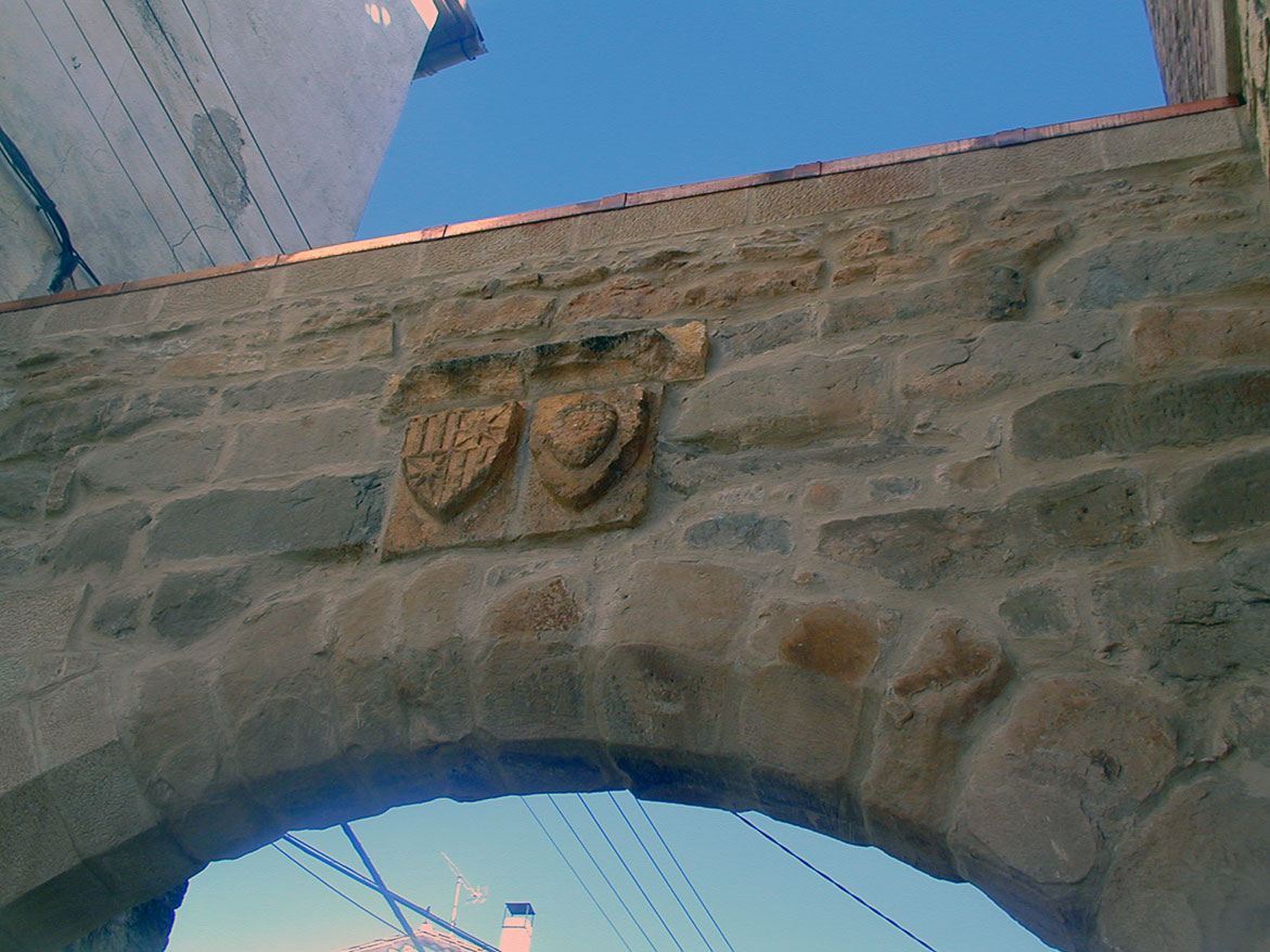
Portal del Sol. Estadilla
The medieval village of Estadilla was tied to the Baronetcy of Castro and growing in the shade of the castle. In order to protect the fledgling village, a magnificent wall was built around it and became a construction that would define the grandeur of the village for “the great brightness and adornment that ensues from fortresses and complete walls with merlons.”
Its gateways were an important urban element being the only access to a walled enclosure. The walls, whatever their original purpose, (defensive, fiscal or representative) created an inside and an outside and the only element that joined them was the doorway. During periods of calm and tranquillity the wall’s gateways lost their original defensive purpose and took on other roles; as the entrance and exit for people and merchandise they acted as physical references for the control of taxes.
Estadilla had four entrances facing the cardinal points and each was flanked by towers: the Portal de la Fuente (located next to the main square), the Portal del Romeo, the Portal del Llenado and the Portal del Sol, which is the only one that remains.
The coats of arms of the Castro and Pinós families decorate the Portal del Sol, communicating a message of power and charged with symbolism. Francisco de Villalpando wrote about these crests; “It appears that each stone is talking and presenting the personality, majesty and authority of the founder.”
From an urban point of view the walls dictated the development of the village for centuries giving rise to a compact layout with narrow streets and passageways above. However, when the walled perimeter became obsolete, the village’s expansion included slums that blurred the urban image once defined by sturdy walls.
The Portal del Sol was also known in the past as the Portal de Santa María due to its proximity to the church of Santa María de la Balsa. Facing the south, it was frequently used by villagers who liked to take in a little sunshine, hence the name “Gate of Sun.” As one of the most accessible areas of the village it soon became the large square that is now surrounded by new buildings that rose out of the slums.
The Portal del Sol, which now constitutes an urban reference of historical and artistic value, evokes that tumultuous time when protection was necessary, when rumours of battles were rife and when clashes and sieges were a constant threat.


Castillo palacio. Permisán
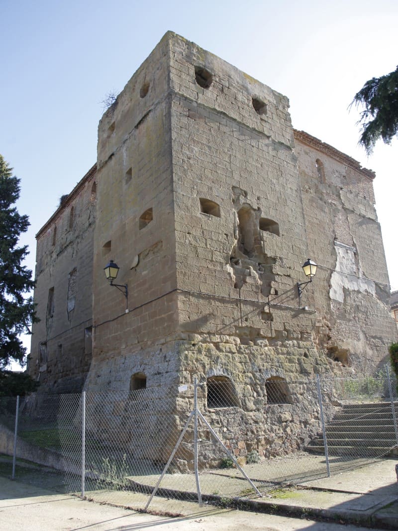
The palace is made up of two sections. The huge quadrangular block made of ashlars (measuring 20 x 14 metres) was used as a house. The square tower (sides each measuring 6 metres) rises at one of the corners and has a defensive air. The tower highlighted the elevation of the building and so a gallery of brick arches was added to the main section to reflect the height of the tower. The walls have large openings where artillery was once stored.


