Rutas en el Somontano
Route of Legends. Adahuesca

Technical information
Type of route: circular hiking and mountain bike route
Departure point: Adahuesca, Legends and Traditions Visitor Centre.
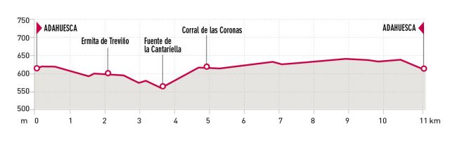
KM: 11,2
Duration: 3 h
Gradient: 145 m
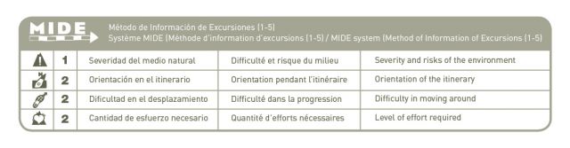
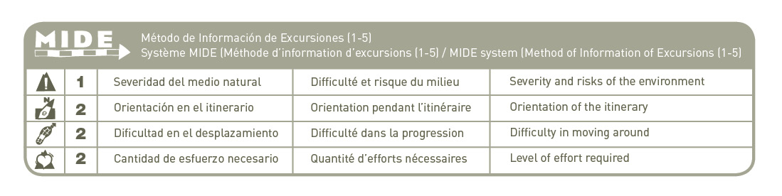
MIDE: 1-2-2-2
Difficulty:
Points of interest
The church of San Pedro, the hermitage of Nuestra Señora del Treviño (late Romanesque), Mediterranean crops, livestock pens and trails, ancient holm oaks, springs, washhouses and well-springs, Crucelós, traditional architecture.
Route description
The ‘Journey of Legends’ route starts and finishes in the village of Adahuesca. It forms a gentle circuit allowing the visitor to enjoy mountainous landscapes and patchwork fields of typical Mediterranean crops such as vines, olives almonds and cereals. The path is also suitable for mountain bikes.
The route is dotted with structures of historic and cultural significance, all set against the magnificent backdrop of the mountains of Somontano. The Trevino chapel, the Courtyard of Crowns, the local parish church and the spring well are just a few examples. In addition to the tangible attractions, the route also reveals the strong links the Somontano people have with the past, through their fiestas, rites, legends, traditions, identities and ethnological elements such as the site of Crucelós.
Through a series of 11 informative panels along the route, the visitor can discover the magical secrets hidden in these legendary paths.
As you will discover, part of the route follows the Somontano section of the Broto to Mequinenza cabañera – an important track used over centuries for the migratory movement of livestock. This particular section crosses the Somontano from north to south, linking Peralta de Alcofea with the Mesón de Sevil.
This informative and enjoyable route can be enjoyed throughout the year, and is particularly dramatic in spring and autumn.
Photo gallery


Map

Ras Vals Way. Castillazuelo
Technical information
Type of route: circular hiking and mountain bike route
Departure point: Castillazuelo, Centro Interpretación Río Vero.
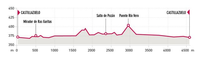
KM: 4,5
Duration: 1h 50 min
Gradient: 50 m
MIDE: 1-2-2-2
Difficulty:
Points of interest
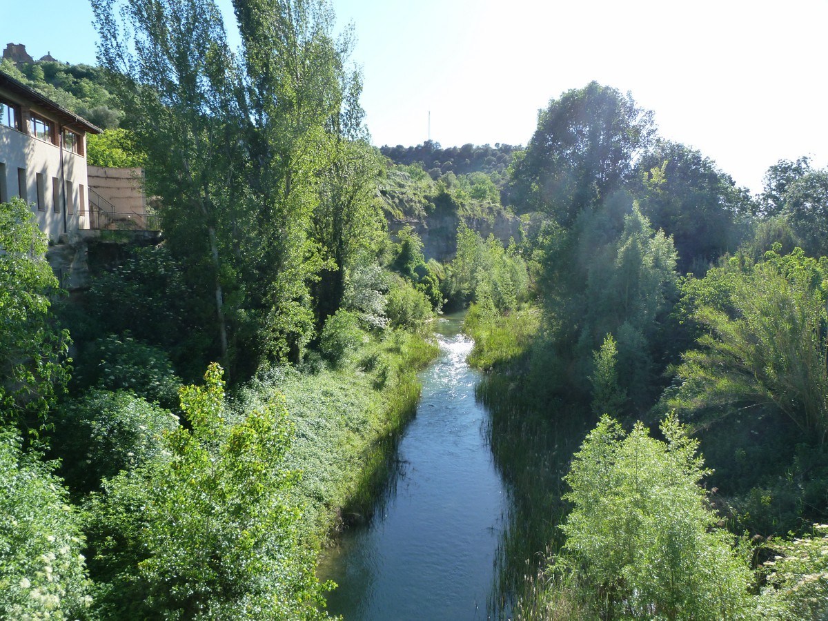
Pozán mill dam, the San Marcos aqueduct (16th c.), riverside flora and fauna.
Route description
Take the steep asphalted street from next to the River Vero Visitor Centre, and after a few metres on the right, you will notice the sign indicating the start of the ancient Camino de Ras Vals. This historic track was used by the farmers of Castillazuelo to reach fields on the outskirts of the village.
Excellent views over Castillazuelo and the River Vero can be enjoyed beyond the railings that mark the first stretch of the footpath. Then just five minutes from the start of the walk, you will reach the Ras Garitas Viewpoint. An informative panel looks out over the valley and highlights some of the more interesting features that can be seen from the platform.
After leaving the viewpoint, which is located at the highest point of the route, the path begins to descend and winds closer towards the groves of the Vero. Various types of vegetation grow along the banks of the river including willows and poplars. The trees in particular are essential to the river environment, as they help to sustain the animal and plant life, and at the same time protect the banks from the erosion caused by high water currents.
At one point along the path, it is possible to clearly make out furrows in the rocks. These are a result of the hundreds of carts that have passed this way over the years, wearing away the rock as they went. Without leaving the track, you will soon arrive at the old Canal of Castillazuelo.
There is a second footpath just next to the canal; a small detour of around 10 minutes will take you the dam of Pozán, or Pozán Waterfall as it is commonly known.
From the waterfall you must double back along the same footpath until you rejoin the canal. Cross over the River Vero by following the aqueduct and follow the path that runs alongside the left bank of the water, heading back towards Castillazuelo. During this pleasant walk, the beauty and size of the regal gall oaks will contribute to the overall perspective of the valley.
Photo gallery


Map

Routes around Somontano

Numerous shorter tracks criss-cross Somontano to create a network of signposted routes.
Many of these provide a learning experience as they have informative tables and panels revealing the many secrets of Somontano and they are easy to complete being designed for the whole family. Other paths follow ancient roads from historical times, which were once trodden by hunters, peddlers, charcoal burners and shepherds. There are also long routes ideal for sports lovers with In addition, where the effort made is compensated by the magnificent views on the way.

