


Camino Natural del Somontano

Technical information
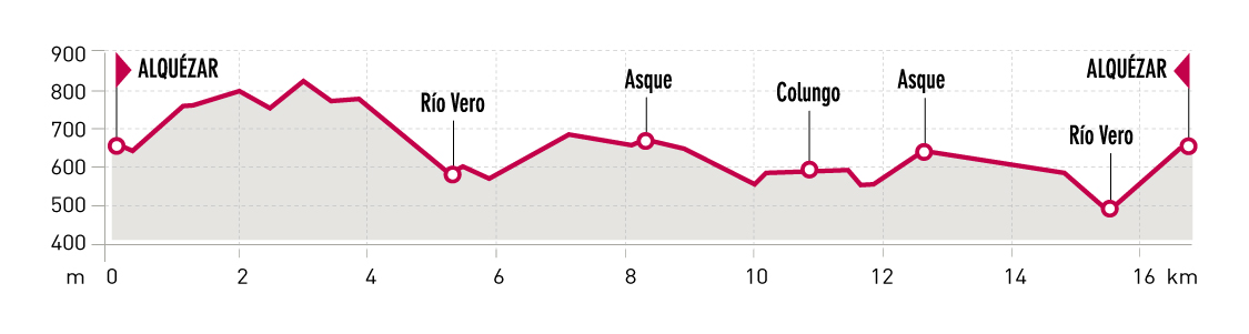
Type of route: circular hiking route
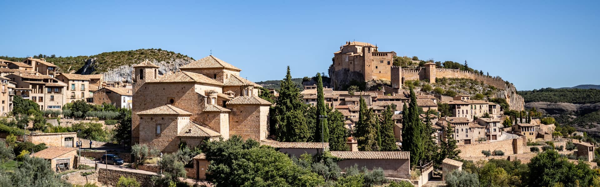
Departure point:: Alquézar
KM: 16,9
Duration: 6 hours
Gradient: 750 m
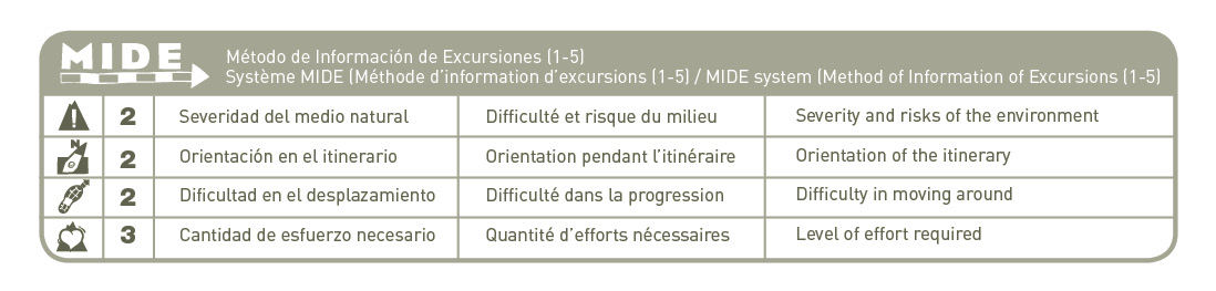
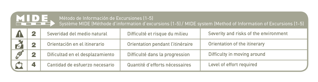
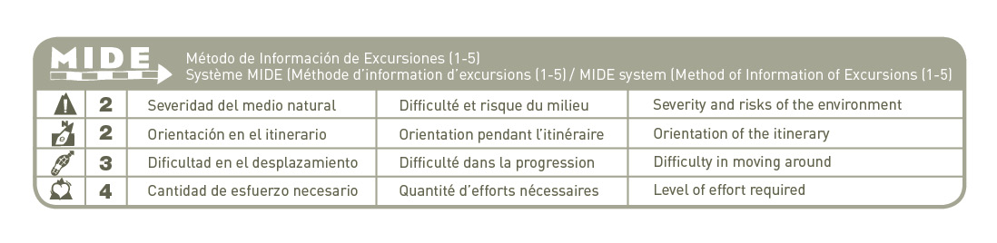
MIDE: 2-2-2-3
Difficulty:
Points of interest
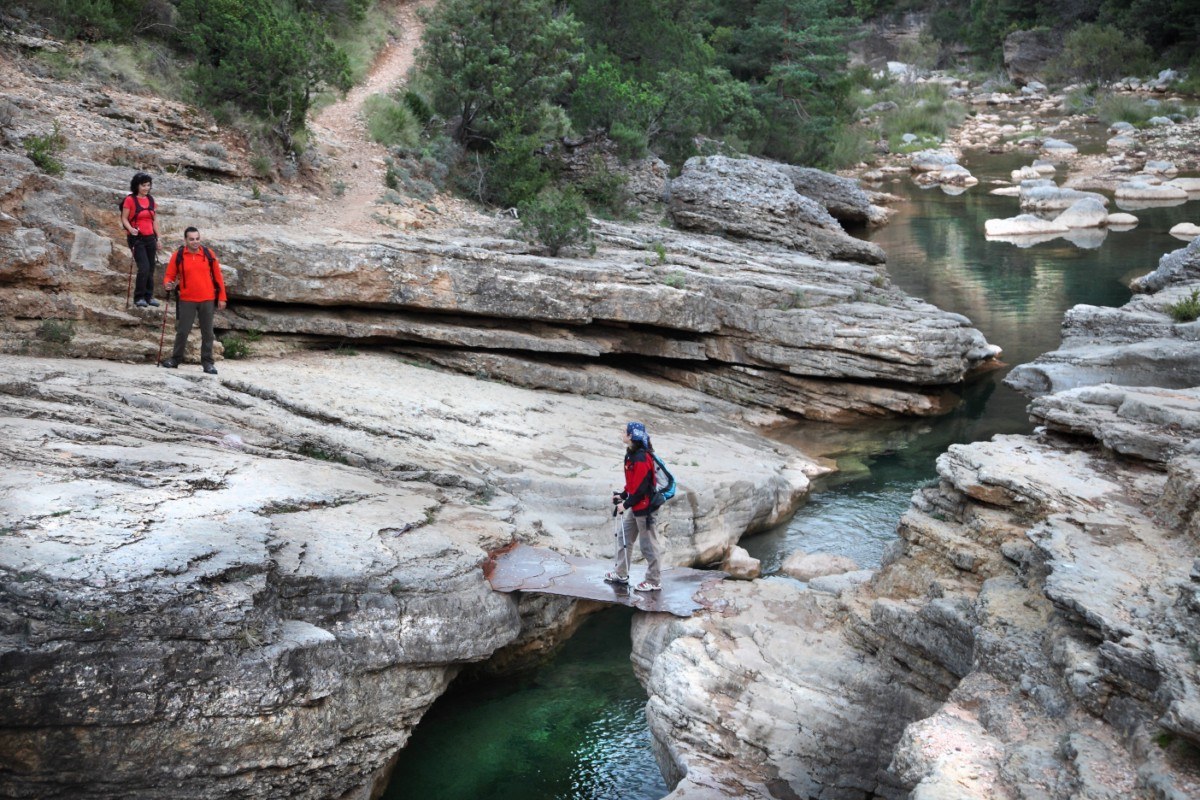
Village mediaeval of Alqueza, San Gregorio chapel, impressive views the Vero canyon, Villacantal Bridge, village of Asque, the Puente del Diablo and Fuendebaños bridge.
Route description
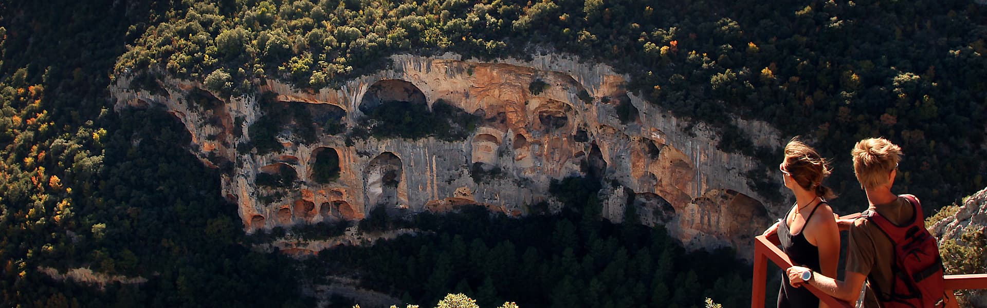
This walk sets off from the path that leads to the San Gregorio chapel and follows the traditional flow of water to the Basacol pools. From here one begins the decent into the Vero canyon that offers impressive views over the town and the canyon. Crossing the river over the Villacantal Bridge where the canyon narrows, it forms an impressive ravine and then goes upstream towards the small village of Asque.The track passes next to the Regacéns cave, a large cavern used in the past as a shelter for livestock that to this day has cave paintings, red and black in colour of Levantine and schematic style.
Moving on, one escapes from the canyon thanks to the Puente del Diablo (Devil´s Bridge). Its spectacular location makes one think of the difficulty and risk faced during its construction and owing to this some legends arise that the devil himself built the bridge. In the conglomerate limestone walls of the canyon you can see in Spring spectacular stemmed plants in flower, up to 60cm in height of La Corona de Rey (King´s Crown/ Saxifraga longifolia), which can shoot more than 500 flowers. The path takes us to Colungo crossing the River Vero once again by the historic Fuendebaños bridge, before returning to Alquezar.
Photo gallery


Map

Technical information
Type of route: lineal hiking route
Departure point: Alquézar
KM: 22
Duration: 8 hours
Gradient: 950 m
MIDE: 2-2-2-4
Dfficulty:
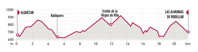
Points of interest
Village of Radiquero, chapel “Ermita de la Virgen de la Viña”, Cautiecho canyon, bridge “el Puente de las Bruxas” and Tranco de las Olas.
Route description
The path follows the San Gregorio path arriving in Radiquero, the Santa Águeda chapel and continues to “la cabañera” (herdsman trail) that linked the low lands (Mequinenza) to the Pyrenees (Broto). The path then diverts, to cross the Canyons of Modovil and Avellaneras, and passes closeby the chapel “Ermita de la Virgen de la Viña”.
From Corral Nuevo, the path continues passing by the palomeras, spectacular karst formations until the narrow pass of the Cautiecho canyon, crossing over the bridge “el Puente de las Bruxas”. In the past, mules and their drivers, loaded with olive oil, flour, wine, potatoes or honey could easily cross this crevice thanks to this simple ingenious and practical bridge, showing us one of the most archaic building solutions used by man to cross and overcome the abysses of the sierra.
With a smooth descent we reach the riverbed of the Isuala Balcés river at the elevation of a Tranco de las Olas, by which the path crosses toward the Collado de las Almunias. This was the traditional way to avoid a difficult stretch when the river Isuala-Balced was swollen..The name of the place refers to the type of construction, consisting of a simple log attached to the rock with metallic hooks, a temporary structure, that would be taken away with eachflood in the canyon. From there, we continue on the track toward Las Almunias de Rodellar.
Photo gallery
Map


Technical information
Type of route: lineal hiking route
Departure point: Las Almunias de Rodellar
KM: 18,5
Duration: 6 hours
Gradient: 700 m
MIDE: 2-2-3-4
Difficulty:
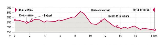
Points of interest
Pasaderas of Pedruel, Peña Falconera or Huevo de Morrano and La Tamara y el Puntillo springs.
Route description
From Las Almunias de Rodellar, you will have to take a track toward las Pasaderas de Pedruel. These Pasaderas (stepping stones) have been one of the traditional ways to cross the rivers in the Sierra of Guara. Here, some carved stones … a prism with a square base are stuck in the riverbed and spaced half a metre from each other, which allow you to cross the Alcanadre.. Once in Pedruel, follow the signs of the old path that go down the Peonera..
All along this walk, one can appreciate how the limestone mixes withthe conglomerate and the wealth and abundance of geomorphology in this territory, which gives us a first hand look at how the landscape was formed.
At this point, the path goes towards the pine forest of Morrano, to later on climb to the base of the Peña Falconera, an impressive stand alone solitary stone. The walk goes around the Stone and heads to the Resurgence of La Tamara. The water that filters in the limestone, can reach the surface through resurgences such as this spring, at the exit of the strait of Fornazos, one of the most beautiful place of the Guara Park.
On this stretch of the Alcanadre river, you will be able to observe the differences of the fluvial erosion on the sandstone, the conglomerates and the limestone. Crossing the river at the Tamara, the path finally arrives at the amazing Salto de Bierge. This dam was built to supply the small hydroelectric power station of Bierge, which then goes on to supplya historical dam used by a mill.
Photo gallery
Map

The Somontano Nature Route lies mainly within the boundaries of the Sierra de Guara Natural Park and crosses the Somontano de Barbastro region, passing through delightful villages such as Colungo, Alquézar, Adahuesca and Bierge.
The Somontano Nature Route, a spectacular footpath that stretches over 50km, links some of the most attractive landscapes in the Sierra de Guara. It is well equipped for walking and includes signposting along its length, which makes it ideal for everyone.
The full route can be undertaken in stages or it can be used to create shorter itineraries that double-back along the same section. Thanks to Somontano’s favourable climate, the footpath can be used throughout the year. There are no steep inclines and there is no prior need for special knowledge, material or equipment.
This route is divided into three stages:
- Stage 1: Alquézar – Asque – Colungo – Alquézar.
- Stage 2: Alquézar – Las Almunias de Rodellar.
- Stage 3: Las Almunias de Rodellar – Salto de Bierge
It’s possible to connect up with the Hoya de Huesca Natural Route in Bierge, which in 132 km leads you up to the “Mallos de Agüero”, crossing all the pre-Pyrenees mountains.

