Rutas en la Sierra de Guara
Footbridges Route. Alquézar
Technical information
Type of route: circular hiking route
Departure point: Alquézar
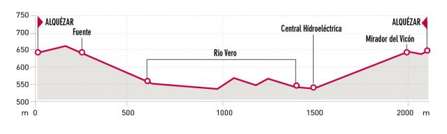
KM: 2,2
Duration: 1 h 30 min
Gradient: 160 m
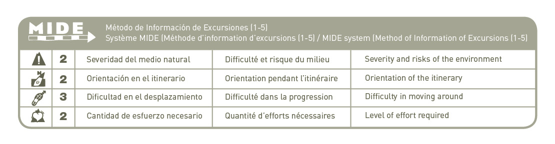
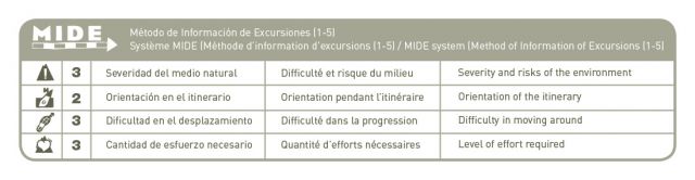
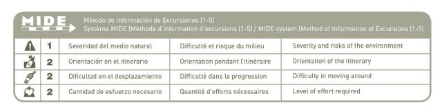
MIDE: 2-2-3-2
Difficulty:
Downloads
Notices, Incidents and rental of helmets: http://pasarelasdealquezar.com
Points of interest
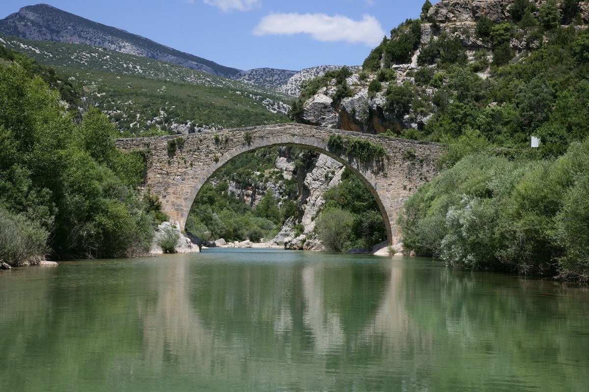
River Vero canyon, historical remains, Fuentebaños bridge and birds of prey.
Route description
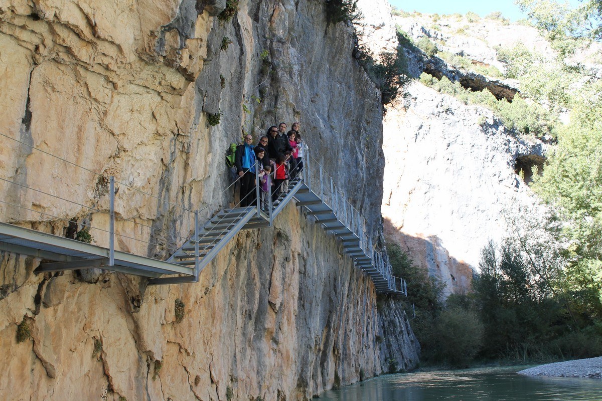
This pleasant and gentle route takes the visitor into the final stretch of the River Vero canyon, where the harmony between rock and water can be fully appreciated. In this beautiful environment it is possible to gain an insight into the huge efforts man has made over the years to harness the power of the river water. The spectacular footbridges are safe and easy to cross and allow access to this unique natural corner of Alquézar.
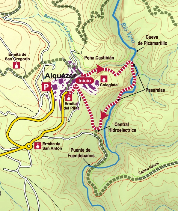
The walk starts in the Plaza Mayor in the centre of Alquézar. Take the street that heads towards the collegiate castle and at the first turn-off to the left, go down a stone ramp. Here, you will see the first sign indicating the “Pasarelas de Vero.” (Footbridges of Vero.)
You will soon come across the first of the wooden bridges, slotted between the Castibián crag to the left, and the walls of the castle on the right. A total of seven stretches of footbridge make up the descent to the River Vero. As you venture deeper, the splendour of the Barranco de la Fuente (Canyon of the Spring) in revealed, characterized by its many small caves and a vegetation adapted to the damp and fresh conditions of the gorges.
Arriving at the riverbed of the Vero, it is worth visiting the cave of Picamartillo, which is situated on the left-hand bank and directly opposite the mouth of the canyon.
The footpath follows the river downstream by means of a spectacular metal gangway attached to the rock of the wall. You will soon come across an old dam, and after following another stretch of metal walkway, will reach the ancient hydroelectric mill of Alquézar. Here, a pool of deep turquoise water is irresistible in warmer weather; a perfect spot for a rest and a dip.
From this point, the path leaves the river behind and snakes between olive groves until it meets with the track heading back towards Alquézar. An alternative is to return directly to the village following the path that leads to the o’Bicon viewpoint.
Photo gallery


Map
Route to the shrine of la Virgen del Castillo. Rodellar
Technical information
Type of route: circular hiking route
Departure point: Rodellar
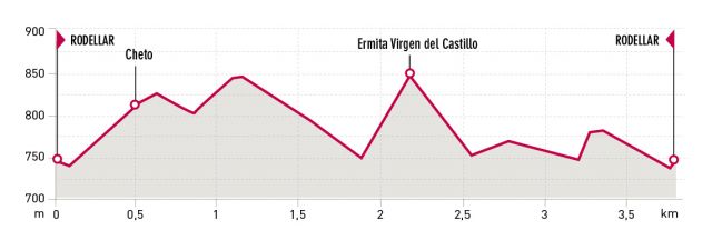
KM: 3,8
Duration: 2 h
Gradient: 240 m
MIDE: 2-2-3-2
Dififculty:

Points of interest
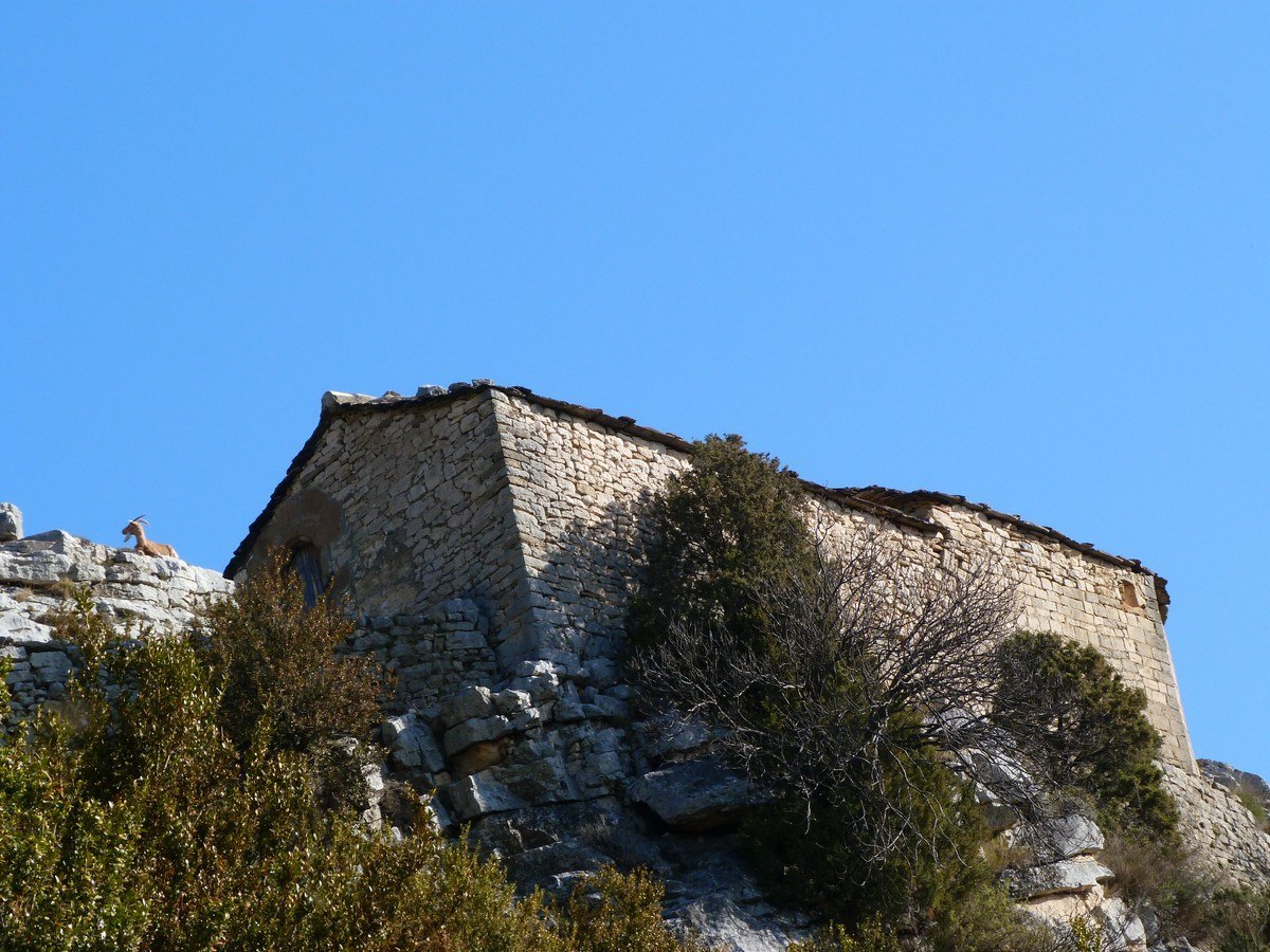
Traditional architecture, dry stone walls, Mediterranean woodland, the village of Cheto, Fonciachas spring, the Romanesque shrine of la Virgen del Castillo, views of the Mascún canyon.
Route description
After parking your car at the entrance to Rodellar, head towards the Honguera neighbourhood of the village. To the right of the houses and next to a small ravine, there is a footpath leading to the hamlet of Cheto, which winds its way through a magnificent forest of holm oak and box wood. A network of skilfully built, dry stone walls mark out both sides of the path and the perimeters of the ancient fields of crops.
In Cheto take the trail to the right, which is clearly marked by one of the many signs along the route. The footpath continues between ancient stone walls, and interestingly the stones of this section are in a vertical position. You may well wonder at the type of equipment used to achieve this unusual effect.
In order to reach the Romanesque chapel of the Virgen del Castillo (Virgin of the Castle), it is necessary to cross the Fornocal and the Virgin ravines This particular part of the walk offers magnificent views over the final section of the Mascún canyon including the Mascún Spring, the Andrebot Gully and the dolphin-shaped hole in the rocks known as ‘Los Ventaneles.’ Once you have reached the bottom of the Virgin ravine, all that remains is to climb the opposite slope to reach your destination of the chapel of the Virgen del Castillo.
It is possible to return to Rodellar along a different route to avoid doubling back through Cheto. After crossing back over the Virgin Ravine, follow the path until you arrive at a signpost which indicates the direction to Rodellar. A little further on you will reach the main path which leads directly back to the village. For those who wish to extend the route, a small detour can be added to reach the bottom of the Mascún canyon, allowing a visit to the Mascún Spring.
Photo gallery


Map

Mascún canyon route: from Rodellar to Otín
Technical information
Type of route: circular hiking route
Departure point: Rodellar
KM: 17,4
Duration: 5 h
Gradient: 650 m
MIDE: 3-2-3-3
Difficulty:

Points of interest
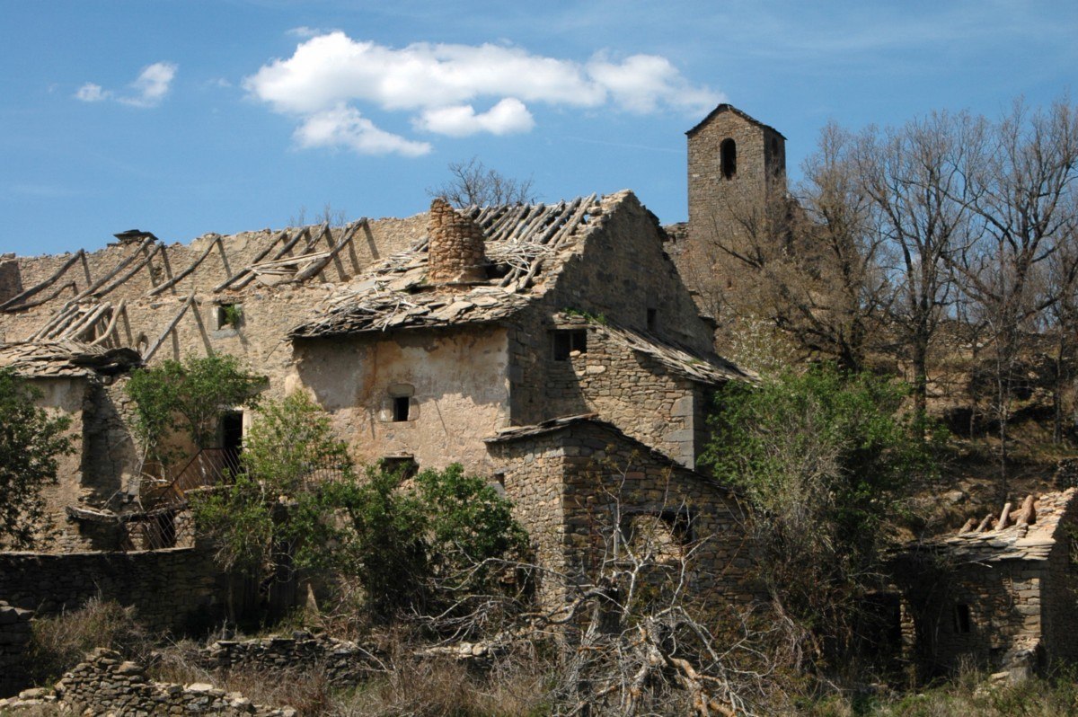
Mascún natural spring, rock needles, the deserted village of Otín, the Romanesque church of Nasarre, the dolmen of Losa Mora.
Route description
This full day excursion will take you deep into the Mascún canyon, which is simply one of the most spectacular and emblematic natural landscapes of the Sierra mountain range. It is known for its fantastic rock formations and other striking features, such as the megalithic stones of Losa Mora and the Romanesque church of Nasarre.
The route begins in the Honguera district of the village of Rodellar. From here take the footpath that leads down to the fluvial bed of Mascún river, keeping your eyes open for the rock-climbers that dot the craggy canyon walls. Once you have reached the bottom, the path will wind its way to the Mascún spring where water flows from the rocks. This fresh water is safe to drink, so fill up containers if necessary. Continuing along the path an arrow will point the way to the Dolmen of Losa Mora to the left, situated deep in the Adrebot Ravine.
After covering a good part of the climb along the narrowing ravine you will reach the area known as the Pardina Seral, where it is still possible to make out the remains of old cultivated terraces on the slopes: long since abandoned. The path heads north across a small gorge before reaching a high ridge with spectacular panoramic views over the central Pyrenees. At this point, it is possible to visit the Dolmen of Losa Mora situated to the right of the path.
A few metres ahead there is a fork in the track. One path leads to the uninhabited hamlet of Nasarre with its well-known Romanesque church, which has been declared a Building of Cultural Interest. Following the other path to the right, signposted as the Historic Path GR1, you will pass by the Pardina of Villanúa before arriving at the small village of Otín, also uninhabited. From Otín take the path known as ‘La Costera de Otín’ to head back to the village of Rodellar. This is one of the best known paths in the Sierra de Guara as it is the route that shows the magnificent grandeur of the Mascún Canyon at its very best. The geological formations known as Ciudadela and the Cuca Bellostas are particular highlights, and are emblematic of the canyon.
Once you have reached the waters of the Mascún river you will rejoin the original path taking you back to Rodellar.
Photo gallery


Map

Route from Pedruel bridge to the Shrine of la Trinidad. Pedruel
Technical information
Type of route: lineal hiking
Departure point: Pedruel bridge
KM: 6
Duration: 2 h
Gradient: 40 m
MIDE: 1-2-2-2
Difficulty:

Points of interest
Pedruel bridge, riverbank flora, the village of Pedruel, traditional architecture, the shrine of La Trinidad, ancient holm oaks, potholes in the Alcanadre river.
Route description
An attractive path leaves from the medieval Pedruel bridge and closely follows the course of the Alcanadre River. The route takes around an hour and is perfect for children. After leaving the bridge behind, the path gently winds past cultivated plots and lush, riverbank vegetation before arriving at the Trinidad chapel, which is surrounded by hundredyear old holm oak trees.
Nearby, the gentle backwaters of the river have created attractive pools that are ideal for a quick dip.
Photo gallery


Map


