Rutas en el Somontano
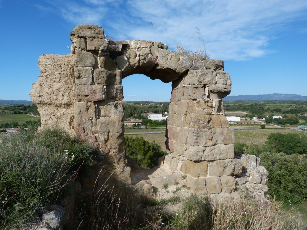
Poyet Way. Castillazuelo
Technical information
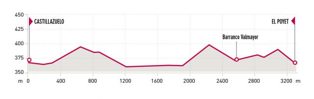
Type of route: return hiking and mountain bike route
Departure point: Castillazuelo, Centro Interpretación Río Vero.
KM: 6,4
Duration: 2 h
Gradient: 190 m
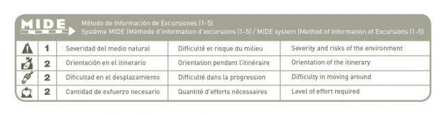
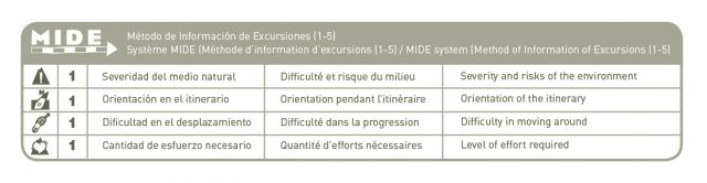
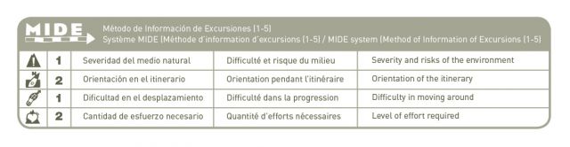
MIDE: 1-2-2-2
Difficulty:
Points of interest
Mediterranean crops, small woods with holm oaks, gall-oaks and poplars (riverbank groves), the ruins of the medieval tower of Poyet, views of the vineyards of the Somontano D.O., the peaks of the Pyrenees and the Sierra de Guara and River Vero Visitor Centre.
Descripción de la ruta
The Poyet Route is ideal for hiking and walking and a good part of the path runs alongside the River Vero. After crossing a number of small gorges and fields of crops, the path continues to the Poyet ruins.
From here it is possible to take in magnificent views of some of the many vineyards and wineries of the D.O. Somontano, as well as the mountains and peaks of the Pyrenees and the Sierra de Guara. Along the way you will pass old almond groves and vineyards that have long since been abandoned, old stone houses and small forests of holm and gall oak.
Photo gallery


Map

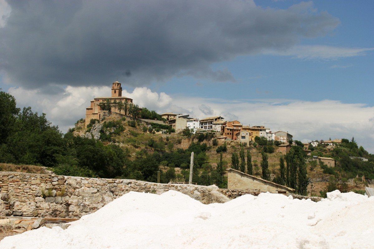
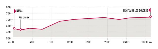
Sanctuary de los Dolores Route. Naval
Technical information
Type of route: lineal hiking route
Departure point: Naval
KM: 6
Duration: 2 h
Gradient: 160 m
MIDE: 1-2-2-2
Difficulty:

Points of interest
Village of Naval , hermitage de los Dolores, panoramic views.
Route description
On the third Sunday of September, the residents of Naval, in pilgrimage, climb to the Virgen de los Dolores chapel.
Situated on the Santa Cruz Hill, the chapel dates back to the 18th century. Between 1968 and 1969 some restoration and remodelling work was undertaken on the building.(chapel, dinning rooms, bedrooms, different rooms, stables.).
Photo gallery


Mapa

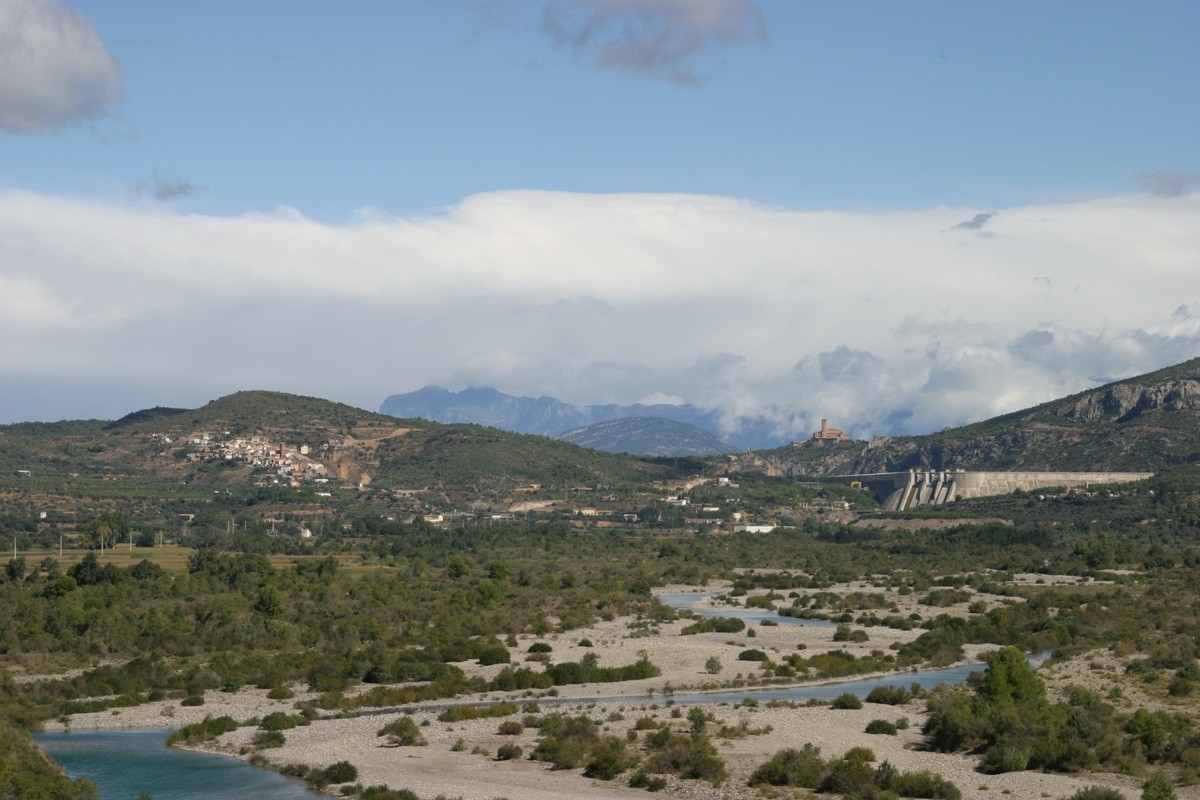
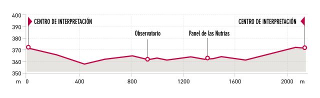
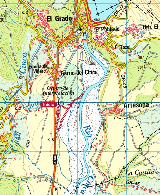
Riverside wildlife route. El Grado
Technical information
Type of route: circular hiking and mountain bike route.
Departure point: El Grado, the Chuaquín Mill
KM: 2,2
Duration: 40 min
Gradient: 30 m
MIDE: 1-1-1-1
Difficulty:
Points of interest
A wooden hut allows walkers to observe animals at peace in their environment as well as fauna associated with woods and river banks.
Route description
The River Cinca is an important fluvial conduit and in this middle section, between the pre-Pyrenees and the Ebro Valley, it acts as a biological corridor for a multitude of species. The predominant vegetation is typical of riverside locations and includes reed beds and riparian groves of willow and poplar. These are up to 1km wide along some stretches of the river and represent some of the best conserved riverside thickets on the Iberian Peninsula. On the riverbanks the fauna includes the wild cat, genet, otter and ocellated lizard and the river is home to barbell and trout.
Photo gallery


Map
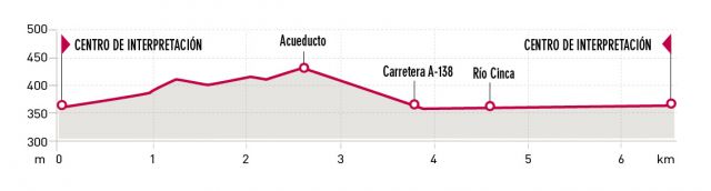
Trees and Aqueduct Route. El Grado
Technical information
Type of route: circular hiking route.
Departure point: El Grado, the Chuaquín Mill
KM: 6,6
Duration: 2 h
Gradient: 75 m
MIDE: 1-2-1-2
Difficulty:
Points of interest
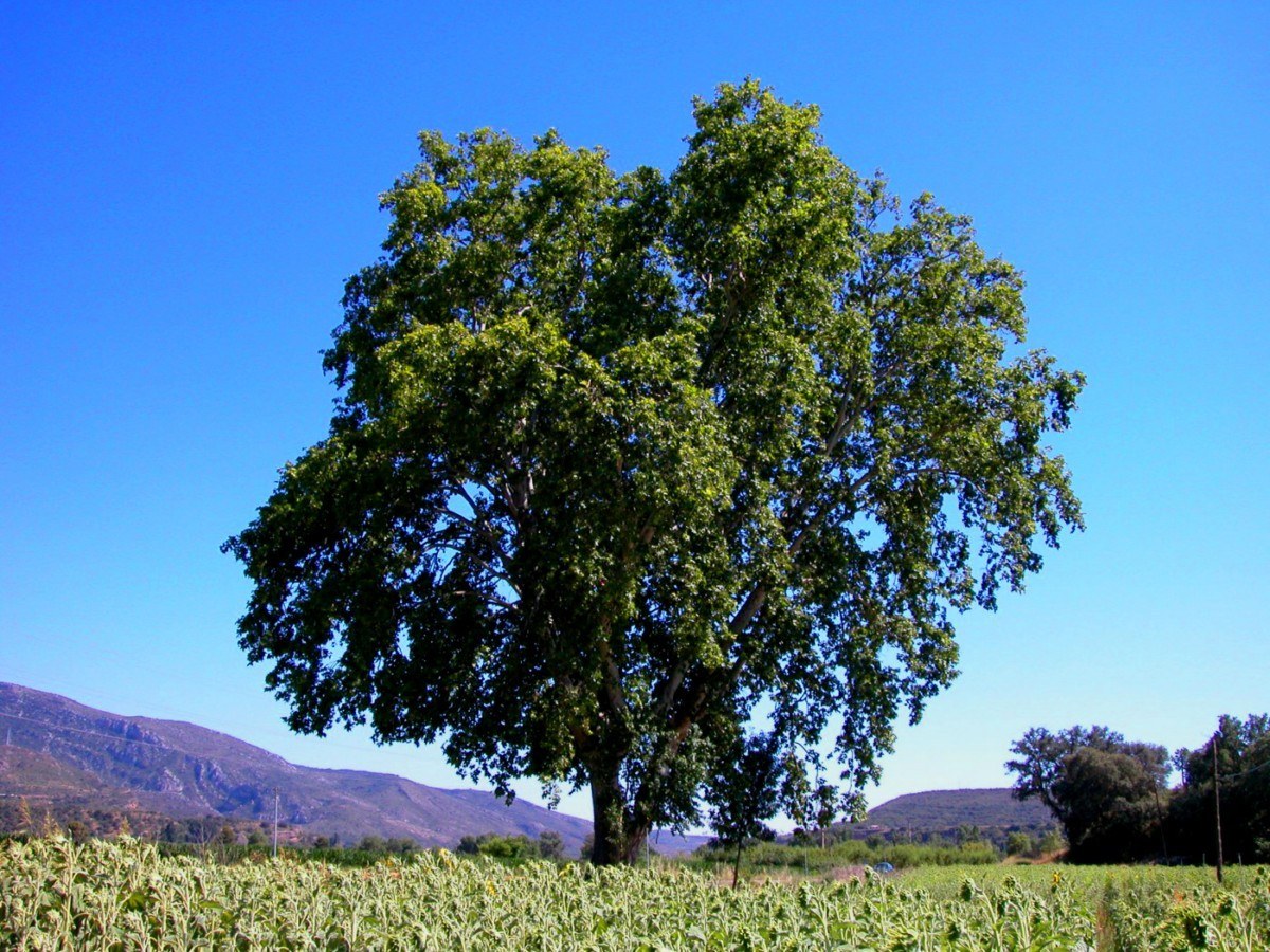
Unique trees, heritage of the hydraulic Cinca Canalsand bird watching.
Route description
This trail, of easy-moderate difficulty, starts at the old flour mill (Molino de Chuaquín), which today has been renovated and transformed into a multiusespace :exhibition room, area dedicated to puppet shows, another for Parchis (Ludo)and the machine room for the old mill.
Throughout the walk you will pass around the impressive Cinca Canal and its aqueducts, discover 7 unique species of tree as well as some of the birds of the area. The Mediterranean forest with its flora and fauna leads down to the crystal clear water of the Cinca River. If you are lucky maybe you might see some birds of prey in acrobatic flight such as the Red Kite.
Photo gallery


Map