Ruta del Agua
Dams, mills, channels and an old electric plant. Alquézar
The River Vero flows underground for a long stretch until emerging in Lecina and from here if runs its course through spectacular canyons and narrow gorges.
Cave art close to Lecina and Alquézar is testimony to the activity of man in this remote area as far back as the pre-historic era. Durant Islamic rule, the Vero acted as a natural communication route between Al-Qsar (Alquézar or fortress) and the Moorish city of Barbastro, capital of the Barbitanya region. Later, the river became a natural corridor for the penetration of Aragonese troops in their advance from Sobrarbe to conquest the flatter land to the south.
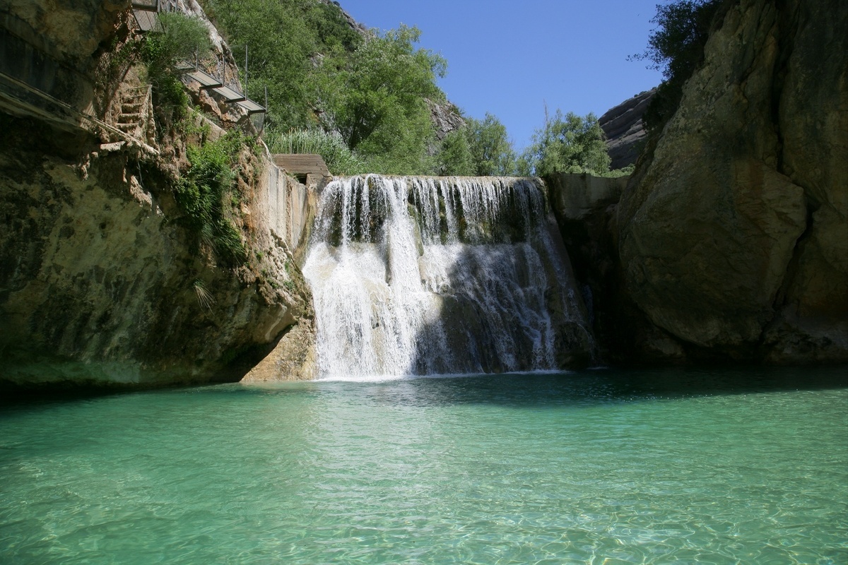
Despite the narrow water flow as it passes by Alquézar, the Vero’s waters have been used for the maximum benefit of man in the past. The mills, dams and bridges that remain are evidence of the intense activity that took place here until recently.
A dam is a barrier that raises the level of the water in order to direct it to a channel to be used as a hydraulic force or to water land. The dam at Alquézar dates back to medieval times and the water held here was channelled to an old mill that no longer exists. Around 1909 the dam was reinforced with cement and a new channel was built, which can still be seen today. This took the water to the turbines of a small electricity plant that had been installed on the site of an old mill.
Travelling down the river, the sheer, calcareous walls give way to more rounded conglomerate rock faces. Beneath these cliffs there is another dam, which was originally used to collect water for the paddles of an ancient fulling mill. The purpose of this mill was to transform open weave cloths into more closely woven fabric. The force of the water moved a wheel that drove mallets, which would beat the cloth to make it more compact. Records date the fulling mill of Alquézar back to the year 1190. Taking into consideration that this type of machine did not emerge until the 12th century, this incipient pre-industrial activity brought great prosperity to the village of Alquézar in the medieval era.
Later, between the 14th and 15th centuries, the dam was put to use to serve a flour mill situated 200 metres downstream. The water from the dam was channelled to a small reservoir and in this way the miller was guaranteed production without being subject to the variable fluctuations of the river flow. The water was fired with great force down to the mill through chutes to drive the millstone and poured out from a space below. These cavities are the only constructive element to differentiate the mill from an old country house.


Public Fountain. Abiego
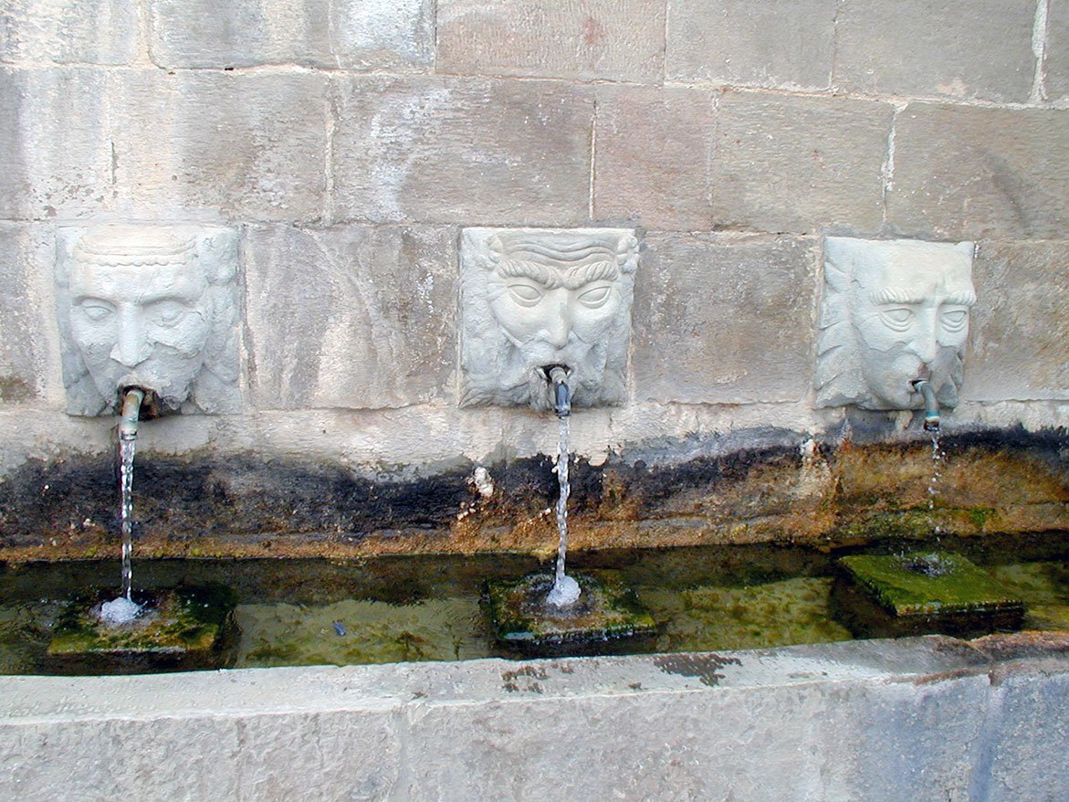
The traditional fountains of Somontano were built in a style that was popular in the 16th century. The design proved so successful that it was used for hundreds of years with little change, right up until the 19th century.
The construction was designed to meet a number of needs; the central piece was the main fountain built for human use; a channel distributed the precious water to various spouts and a little further away there was the washing area. On some occasions, water was stored in reservoirs to be used in mills and factories. A series of irrigation ditches used for watering crops in nearby fields and allotments was the final addition to the system.
Almost all of the fountains in Somontano follow the same model. The structures are always crowned with a cornice whose design is simple, yet the geometric simplicity and careful creation contributes greatly to their beauty. Very few display ornate decoration; however the fountain of Abiego boasts carved masks from which the water spouts, imitating more cultured models.

Los Doce Caños fountain. Estadilla
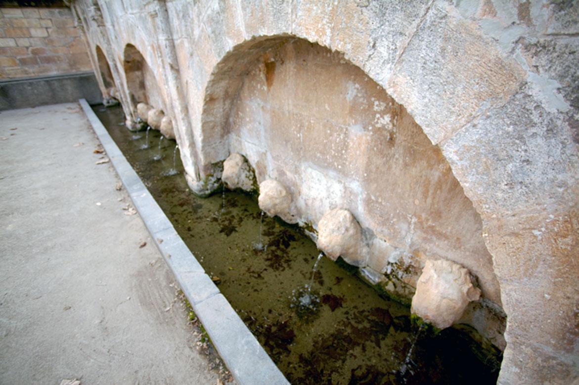
The fountain lies near to the vegetable gardens and village allotments. It stands on the site of the most important spring in the area providing more than 60 litres of water per second. The water maintains a temperature of 15-16ºC throughout the year.
The water is brought to the surface by means of a 35 metre tunnel excavated from the rock. It is used to water the vegetable gardens in the immediate vicinity and, by means of underground irrigation channels, also carries water to olive groves, orchards and vineyards.
The fountain dates to 1735 as can be seen from the date etched on its façade and was one of the biggest to be constructed in the Somontano region. In addition to moulded pilasters, capitals with rosettes, chunky leaves and scrolls, it also boasts twelve lions’ heads that open up into water spouts. This style denotes a significant knowledge of classicism on the part of the stone masons.
Due to its structure and decoration it is more representative of an ornamental model of fountain rather than the traditional and more functional style. These were built with a decorative and symbolic function in villages and towns, representing the pride of a society and of the municipal authorities who built them. The patronage of this model is reflected in the coat of arms that crowns the structure, leaving no doubt who was responsible for bringing water and prosperity to the villagers.


Reservoir. El Grado
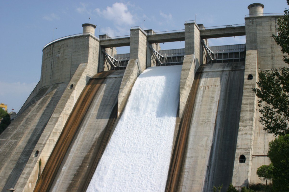
The construction of this huge reservoir and that of the El Grado dam (1969) marked an important change in both the landscape and lifestyle of the village.
It covers a total area of 1,273 hectares and holds 400 Hm3 of water. It is part of the extensive irrigation system of the Alto Aragon region as the Cinca canal originates here. It also has a hydro-electric element thanks to the water that pours over the large dam.
The reservoir offers the visitor an unforgettable spectacle; the size and setting are dramatic and the blue of the sky is perfectly reflected in the deep blue surface of the water. The top of the dam is an excellent place to take in views of the reservoir; the unmistakable Torreciudad shrine set against the background of the Pyrenees and the Cinca valley with its characteristic riverside vegetation. In addition, patient observers will see trout and other fish jumping from the water.
A number of competitions related to sub-aquatic orientation are traditionally held in the El Grado dam, as organised by the Aragonese Federation of Sub-Aquatic Activities (FARAS.) Over the last few years, it is also been one of the venues to carry out the sub-aquatic manoeuvres of the Section of Amphibious Activities (SAA) and the Pontoon Regiment of Monzalbarba (Zaragoza.)
Visits:
Mail: [email protected]
Teléfono: 976 711 045


